Virginia State Route 285
| ||||
|---|---|---|---|---|
| Tinkling Spring Road | ||||
 | ||||
| Route information | ||||
| Maintained by VDOT | ||||
| Length: | 1.85 mi[1] (2.98 km) | |||
| Existed: | late 1990s – present | |||
| Major junctions | ||||
| South end: |
| |||
|
| ||||
| North end: |
| |||
| Location | ||||
| Counties: | Augusta | |||
| Highway system | ||||
| ||||

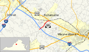
State Route 285 (SR 285) is a primary state highway in the U.S. state of Virginia. Known as Tinkling Spring Road, the state highway runs 1.85 miles (2.98 km) from SR 608 and SR 935 near Fishersville north to U.S. Route 250 (US 250) in Fishersville in eastern Augusta County.
Route description
_near_Orr_Drive_in_Fishersville%2C_Augusta_County%2C_Virginia.jpg)
SR 285 begins at its intersection with SR 608 and SR 935 (Expo Road) southwest of Fishersville. Tinkling Spring Road continues south as SR 608 toward Stuarts Draft. SR 285 heads northeast as a two-lane road through a diamond interchange with Interstate 64 and passes the Augusta Health medical center. The state highway veers east and briefly parallels CSX's North Mountain Subdivision before reaching its northern terminus at US 250 (Jefferson Highway) just south of its crossing of the railroad in the village of Fishersville.[1][2]
Major intersections
The entire route is in Augusta County.
| Location | mi[1] | km | Destinations | Notes | |
|---|---|---|---|---|---|
| | 0.00 | 0.00 | south end of SR 608 overlap | ||
| | 0.21 | 0.34 | Exit 91 (I-64) | ||
| Fishersville | former SR 273 south | ||||
| 1.85 | 2.98 | north end of SR 608 overlap | |||
| 1.000 mi = 1.609 km; 1.000 km = 0.621 mi | |||||
References
- 1 2 3 "2010 Traffic Data". Virginia Department of Transportation. 2010. Retrieved 2012-01-05.
- ↑ Google (2012-01-05). "Virginia State Route 285" (Map). Google Maps. Google. Retrieved 2012-01-05.