Virginia State Route 99
| ||||
|---|---|---|---|---|
 | ||||
| Route information | ||||
| Maintained by VDOT | ||||
| Length: | 5.20 mi[1] (8.37 km) | |||
| Existed: | 1933 – present | |||
| Major junctions | ||||
| South end: |
| |||
|
| ||||
| North end: |
| |||
| Location | ||||
| Counties: | Pulaski | |||
| Highway system | ||||
| ||||

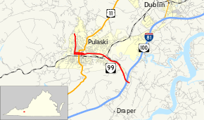
State Route 99 (SR 99) is a primary state highway in the U.S. state of Virginia. The state highway runs 5.20 miles (8.37 km) from the north town limit of Pulaski east to SR F-047 just east of Interstate 81 (I-81) and SR 100 at McAdam.
Route description
SR 99 begins at the north town limit of Pulaski. The highway continues north into unincorporated Pulaski County as SR 738 (Robinson Tract Road). SR 99 heads south as two-lane Randolph Avenue. At the west edge of downtown, SR 99 splits into a one-way pair. Westbound SR 99 turns onto Randolph Avenue from 3rd Street while eastbound SR 99 turns from Randolph Avenue onto Main Street, which parallels Peak Creek through downtown. Each direction of SR 99 follows two-way streets east to Jefferson Avenue, where both Main and 3rd become one-way. One block to the east, SR 99 intersects U.S. Route 11 (Washington Avenue). Two blocks east of US 11, Main Street becomes a four-lane divided highway as the two directions of the state highway come together. SR 99 gains a median west of Bob White Boulevard, where the highway reduces to two lanes, begins to curve to the south, and crosses Norfolk Southern Railway's Pulaski District and Peak Creek. At the east town limit of Pulaski, the state highway becomes Count Pulaski Drive, which expands to a four-lane divided highway shortly before reaching its partial cloverleaf interchange with I-81 and SR 100 and, just to the south, its eastern terminus at SR F-047 (Kirby Road) in the hamlet of McAdam.[1][2]
History
SR 99 east of downtown Pulaski was initially part of State Route 10, supplemented with U.S. Route 11 in 1926. In the early 1930s, US 11 was rerouted along its current route south of Pulaski, but SR 10 remained. The road from Pulaski northwest for 6.20 miles (9.98 km) was added to the state highway system in 1932[3] as State Route 228.[4] In the 1933 renumbering, SR 228, as well as SR 212 north of McAdam, became State Route 99. (The rest of SR 212 became State Route 100.) The rest of the road to the Bland County line was added in 1936,[5] and in 1937 it was completed to SR 42 at Mechanicsburg.[6] In 1952, the state decided to transfer the whole road northwest of Pulaski to the secondary system "when present primary funds set up for its improvement are expended";[7] the former SR 99 became State Route 738 then.
Major intersections
The entire route is in Pulaski County.
| Location | mi[1] | km | Destinations | Notes | |
|---|---|---|---|---|---|
| McAdam | 0.00 | 0.00 | former SR 100 | ||
| 0.19 | 0.31 | Exit 94 (I-81) | |||
| Pulaski | 3.77 | 6.07 | two-block overlap (southbound only) | ||
| 5.20 | 8.37 | Pulaski town limit | |||
| 1.000 mi = 1.609 km; 1.000 km = 0.621 mi | |||||
References
- 1 2 3 "2010 Traffic Data". Virginia Department of Transportation. 2010. Retrieved 2011-10-20.
- Pulaski County (PDF)
- ↑ Google (2011-10-20). "Virginia State Route 99" (Map). Google Maps. Google. Retrieved 2011-10-20.
- ↑ State Highway Commission of Virginia (July 27–29, 1932). Minutes of Meeting (PDF) (Report). Marion, Roanoke, and Richmond, VA: Commonwealth of Virginia., page 16
- ↑ State Highway Commission of Virginia (July 19, 1932). Minutes of Meeting (PDF) (Report). Richmond, VA: Commonwealth of Virginia., page 10
- ↑ State Highway Commission of Virginia (August 12, 1936). Minutes of Meeting (PDF) (Report). Richmond, VA: Commonwealth of Virginia., page 24
- ↑ State Highway Commission of Virginia (November 9, 1937). Minutes of Meeting (PDF) (Report). Richmond, VA: Commonwealth of Virginia., page 25
- ↑ State Highway Commission of Virginia (May 4–7, 1952). Minutes of Meeting (PDF) (Report). Roanoke and Richmond, VA: Commonwealth of Virginia., page 8
External links
| < SR 227 | District 2 State Routes 1928–1933 |
none |