SS Persia (1900)
 Postcard of SS Persia at Aden, c.1900 | |
| History | |
|---|---|
| Name: | SS Persia |
| Owner: | Peninsular & Oriental Steam Navigation Company |
| Port of registry: | London |
| Builder: | Caird & Company, Greenock |
| Yard number: | 295 |
| Launched: | 13 August 1900 |
| Fate: | Torpedoed and sunk, 30 December 1915 |
| General characteristics [1] | |
| Type: | Cargo-passenger ship |
| Tonnage: | 7,974 GRT |
| Length: | 499 ft 8 in (152.30 m) |
| Beam: | 53 ft 3 in (16.23 m) |
| Draught: | 24 ft 5 in (7.44 m) |
| Propulsion: | Triple expansion steam engine |
| Speed: | 18 knots (33 km/h; 21 mph) |
SS Persia was a P&O passenger liner, built in 1900 by Caird & Company, Inverclyde, Greenock, Scotland. It was torpedoed and sunk without warning on 30 December 1915, by German U-boat U-38.
History
499 feet 8 inches (152.30 m) long, with a beam of 53 feet 3 inches (16.23 m), draft of 24.5 feet (7.5 m) and a size of 7,974 gross register tons (GRT), Persia carried triple expansion steam engines capable of driving the ship at 18 knots (33 km/h; 21 mph).[1]
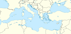
Persia was sunk off Crete, while the passengers were having lunch, on 30 December 1915, by German World War I U-Boat ace Max Valentiner (commanding SM U-38). Persia sank in five to ten minutes, killing 343 of the 519 aboard. The sinking was highly controversial, since it broke naval international law, or the "Cruiser Rules", which stated that merchant ships could be stopped and searched for contraband, but could only be sunk if the passengers and crew were put in a place of safety (for which, lifeboats on the open sea were not sufficient). Instead, the U-Boat fired a torpedo with no warning, and made no provision for any survivors. This action took place under Germany’s policy of unrestricted submarine warfare, but broke the Imperial German Navy’s own restriction on attacking passenger liners, the Arabic pledge.
At the time of sinking, Persia was carrying a large quantity of gold and jewels belonging to the Maharaja Jagatjit Singh, though he himself had disembarked at Marseilles. Among the passengers to survive were Walter E. Smith, a British Member of Parliament, Colonel Charles Clive Bigham, son of Lord Mersey, and John Douglas-Scott-Montagu, 2nd Baron Montagu of Beaulieu. His secretary (and mistress) Eleanor Thornton, who was the model for the Rolls-Royce "Spirit of Ecstasy" mascot by Charles Sykes, died. Also among the dead were Robert N. McNeely, American Consul at Aden and a former North Carolina state senator from Union County, Robert Vane Russell, and American missionary Rev. Homer Russell Salisbury.[2]
Only 15 of the women on board survived, among them British actress Ann Codrington (The Rossiter Case), who was pregnant with her daughter, Patricia Hilliard. Ann lost her mother, Mrs. Helen Codrington.
Sixty-seven crewmen from the Portuguese colony of Goa perished on the SS Persia. Most of them were stewards.[3]
The sinking was front page news on many British newspapers, including the Daily Mirror and the Daily Sketch.
The wreck of Persia was located off Crete in 2003 at a depth of 10,000 feet (3,000 m), and an attempt was made to salvage the treasure located in the bullion room. The salvage attempt met with limited success, retrieving artifacts and portions of the ship, and some jewels from the bullion room.[4]
See also
References
- 1 2 "SS Persia". Clyde-built Ship Database. 2013. Retrieved 25 February 2013.
- ↑ "The Story of the Week". The Independent. 1916. Retrieved 2013-11-23.
Besides Consul McNeeley it seems there was another American drowned, for among the missing is the Rev. Dr. Homer R. Salisbury, a Seventh Day Adventist missionary, who came on board at Marseilles to go to India. He came from Battle Creek ...
- ↑ Commonwealth War Graves Commission data, analyzed by Clifford J Pereira
- ↑ "Salvaging a sense of history". The Scotsman. 19 January 2004. Retrieved 25 February 2013.
External links
| Wikimedia Commons has media related to SS Persia (ship, 1900). |
Coordinates: 34°10′00″N 26°00′00″E / 34.16667°N 26.00000°E
| Shipwrecks |
|
|---|---|
1914 November 1915 | |