Sainte-Pience
| Sainte-Pience | |
|---|---|
|
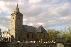
The church of Sainte-Pience | |
 Sainte-Pience | |
|
Location within Normandy region  Sainte-Pience | |
| Coordinates: 48°45′52″N 1°18′05″W / 48.7644°N 1.3014°WCoordinates: 48°45′52″N 1°18′05″W / 48.7644°N 1.3014°W | |
| Country | France |
| Region | Normandy |
| Department | Manche |
| Arrondissement | Avranches |
| Canton | Bréhal |
| Intercommunality | Avranches - Mont-Saint-Michel |
| Government | |
| • Mayor (2008–2014) | Rolande Martinet |
| Area1 | 8.68 km2 (3.35 sq mi) |
| Population (1999)2 | 238 |
| • Density | 27/km2 (71/sq mi) |
| Time zone | CET (UTC+1) |
| • Summer (DST) | CEST (UTC+2) |
| INSEE/Postal code | 50535 / 50870 |
| Elevation |
105–201 m (344–659 ft) (avg. 203 m or 666 ft) |
|
1 French Land Register data, which excludes lakes, ponds, glaciers > 1 km² (0.386 sq mi or 247 acres) and river estuaries. 2 Population without double counting: residents of multiple communes (e.g., students and military personnel) only counted once. | |
Sainte-Pience is a former commune in the Manche department in Normandy in north-western France. On 1 January 2016, it was merged into the new commune of Le Parc.[1]
See also
References
- ↑ Arrêté préfectoral 4 November 2015 (French)
| Wikimedia Commons has media related to Sainte-Pience. |
This article is issued from Wikipedia - version of the 4/5/2016. The text is available under the Creative Commons Attribution/Share Alike but additional terms may apply for the media files.