Salt Creek Oil Field
The Salt Creek Oil Field is located in Natrona County, Wyoming.[2] By 1970, more oil had been produced by this field than any other in the Rocky Mountains region and accounted for 20 percent of the total production in Wyoming.[3]
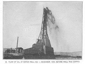
Petroleum seeps in the area were known before 1880, but oil strikes near Lander led to claims by Schoonmaker and Iba.[4] In 1889 the first well to strike oil was drilled in the Shannon pool by P.M. Shannon, president of the Pennsylvania Oil & Gas Company, who in 1895 built an oil refinery in Casper to process the oil.[5] Dr. Porro, an Italian geologist working for the Dutch company Petroleum Maatschappij Salt Creek in 1906, located the Dutch No. 1 near a large oil seep south of the Shannon wells, which was drilled in 1908.[6] The "gusher" well reached an oil sand after drilling through 1,000 feet (300 m) of shale.[7]
In 1915, a portion of the Teapot Dome was made Naval Petroleum Reserve Number 3.[8]
Geology
The field is on an anticline with 1,500 feet (460 m) of closure, which formed in the Late Cretaceous or Early Tertiary.[3] The anticline has two distinct domes, the "Salt Creek Dome" to the north and the "Teapot Dome" to the south.[9] Production is from stratigraphic traps in the Lakota, Sundance and Tensleep formations plus two Frontier Formations, which is an offshore bar sandstone, all of which are interbedded with marine shales.[3] This second Frontier formation extends into the Teapot Dome to the south.[10] The Frontier lies between the Mowry Shale and Niobrara Formation.[3]
-

Salt Creek Oil Field Stratigraphy[1]
-
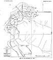
Shannon Oil Pool in Salt Creek Oil Field[2]
-
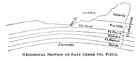
Geological section of Salt Creek Oil Field[3]
- ^ Wegemann, p. 13
- ^ Wegemann, Plate III
- ^ E/MJ, Engineering and Mining Journal (Public domain ed.). McGraw-Hill. 1896. p. 60.
Notes
Bibliography
- Barlow, J.A. Jr., and Haun, J.D., 1970, Regional Stratigraphy of Frontier Formation and Relation to Salt Creek Field, Wyoming, in Geology of Giant Petroleum Fields, Halbouty, M.T., editor, AAPG Memoir 14, Tulsa: American Association of Petroleum Geologists.
- Wegemann, C.H., 1911, The Lander and Salt Creek Oil Fields, Wyoming, US Dept. of the Interior USGS Bulletin 452, Washington: Government Printing Office. (Public domain ed.)
- Wegemann, C.H., 1918, The Salt Creek Oil Field, Wyoming, US Dept. of the Interior USGS Bulletin 670, Washington: Government Printing Office. (Public domain ed.)
External links
Coordinates: 43°23′14″N 106°22′49″W / 43.38722°N 106.38028°W