Samalae'ulu
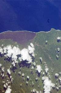
Samalae'ulu inland and the south east of the black lava fields along the coastline. (NASA photo, 2009
Samalae'ulu is a village on the northeast side of Savai'i island in Samoa.[1] The village is part of the electoral constituency (Faipule District) Gaga'emauga I which includes the neighbouring villages of Patamea and the smaller settlement of Mauga which is built around a volcanic crater.
The population of Samalae'ulu is 943 (2006 Census), making it one of the more populous villages in Savai'i.[2]
During the volcani eruption of Mt Matavanu (1905 - 1911), lava flowed between Samalae'ulu and Saleaula to the west, forcing villagers to move from the coast to its present inland location.
The village is situated on the main island highway about a 40-minutes drive north west from Salelologa ferry terminal and township.
References
- ↑ "Samoa Territorial Constituencies Act 1963". Pacific Islands Legal Information Institute. Retrieved 19 December 2009.
- ↑ "Population and Housing Census Report 2006" (PDF). Samoa Bureau of Statistics. July 2008. Retrieved 19 December 2009.
Traditional center: Saleaula | ||
| Villages | 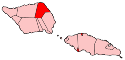 | |
| Landmarks |
| |
| Conservation & Environment | ||
| Education & Schools | ||
| Electoral constituencies: Faipule Districts |
| |
This article is issued from Wikipedia - version of the 11/27/2015. The text is available under the Creative Commons Attribution/Share Alike but additional terms may apply for the media files.