San Bernardino, Switzerland
San Bernardino is a mountainous village in the canton of Graubünden in Switzerland. It is the southern entry point to the San Bernardino tunnel, that complemented the road over the San Bernardino Pass in 1967, opening a new all-year-round road to crossing the alps.
The village is part of the municipality of Mesocco. The language spoken is Italian, one of the three official languages in the canton of Graubünden.
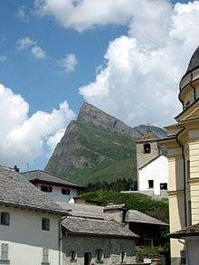
The church dates from around 1450, only years before the Viamala gorge bridge was opened for traffic, multiplying traffic across the pass.
Traffic
The old Mulattiera is still visible and in good condition, this was the path for horses before the construction of a road in 1770 by the adjacent municipalities. In 1812 the state (or canton) of Graubünden built a new road that is actually the one still in use for local traffic and across the pass, whereas the tunnel traffic uses a newly built road that avoids serpentines to allow a fluent traffic.
The walls were built then as dry walls and were restored in 1995 because the road has still to work as a replacement for the tunnel if it has to be closed. The restoration was completed with a minimum amount of concrete reinforcements.[1]
Geography
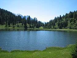
Lagh Doss is located close to the village. The municipality encloses Val Curciusa, a valley lying north of Bocchetta di Curciusa and therefore emptying its waters towards the Rhine river and the North Sea instead of the Adria as in most Italian spoken areas of the canton of Graubünden.
Weather
| Climate data for S. Bernardino (1981-2010) | |||||||||||||
|---|---|---|---|---|---|---|---|---|---|---|---|---|---|
| Month | Jan | Feb | Mar | Apr | May | Jun | Jul | Aug | Sep | Oct | Nov | Dec | Year |
| Average high °C (°F) | 0.6 (33.1) |
0.7 (33.3) |
3.2 (37.8) |
5.8 (42.4) |
10.8 (51.4) |
15.1 (59.2) |
17.8 (64) |
17.2 (63) |
13.2 (55.8) |
9.2 (48.6) |
3.8 (38.8) |
1.0 (33.8) |
8.2 (46.8) |
| Daily mean °C (°F) | −3.6 (25.5) |
−3.6 (25.5) |
−0.9 (30.4) |
1.9 (35.4) |
6.5 (43.7) |
10.5 (50.9) |
13.0 (55.4) |
12.4 (54.3) |
8.9 (48) |
4.9 (40.8) |
0.0 (32) |
−3.0 (26.6) |
3.9 (39) |
| Average low °C (°F) | −7.6 (18.3) |
−7.5 (18.5) |
−4.7 (23.5) |
−1.5 (29.3) |
2.6 (36.7) |
6.0 (42.8) |
8.3 (46.9) |
8.1 (46.6) |
5.0 (41) |
1.3 (34.3) |
−3.3 (26.1) |
−6.5 (20.3) |
0.0 (32) |
| Average precipitation mm (inches) | 89 (3.5) |
62 (2.44) |
95 (3.74) |
171 (6.73) |
216 (8.5) |
188 (7.4) |
188 (7.4) |
193 (7.6) |
202 (7.95) |
182 (7.17) |
162 (6.38) |
105 (4.13) |
1,854 (72.99) |
| Average snowfall cm (inches) | 95.3 (37.52) |
77.8 (30.63) |
76.4 (30.08) |
92.8 (36.54) |
13.6 (5.35) |
0.5 (0.2) |
0 (0) |
0 (0) |
1.4 (0.55) |
9.9 (3.9) |
64.6 (25.43) |
89.4 (35.2) |
521.7 (205.39) |
| Average precipitation days (≥ 1.0 mm) | 7.5 | 6.7 | 8.5 | 11.2 | 14.7 | 12.0 | 11.5 | 12.4 | 10.1 | 10.7 | 9.4 | 8.2 | 122.9 |
| Average snowy days (≥ 1.0 cm) | 8.9 | 7.5 | 7.4 | 8 | 1.8 | 0.1 | 0 | 0 | 0.2 | 1.6 | 6.9 | 8.6 | 51 |
| Average relative humidity (%) | 63 | 64 | 65 | 71 | 74 | 71 | 71 | 73 | 75 | 76 | 71 | 68 | 70 |
| Mean monthly sunshine hours | 101 | 109 | 140 | 120 | 125 | 150 | 172 | 159 | 138 | 114 | 88 | 88 | 1,504 |
| Source: MeteoSwiss [2] | |||||||||||||
External links
- San Bernardino, Switzerland in German, French and Italian in the online Historical Dictionary of Switzerland.
 Media related to San Bernardino, Switzerland at Wikimedia Commons
- (English) San Bernardino on Graubünden Ferien, official tourism board for holidays in switzerland in this area.
References
- ↑ Historic Road dating 1812 being restored (german)
- ↑ "Climate Norm Value Tables". Climate diagrams and normals from Swiss measuring stations. Federal Office of Meteorology and Climatology (MeteoSwiss). Retrieved 23 January 2013. The weather station elevation is 1,638 meters above sea level.
Coordinates: 46°27′N 9°12′E / 46.450°N 9.200°E