Sanana Island
 | |
| Geography | |
|---|---|
| Location | South East Asia |
| Coordinates | 2°12′00″S 125°55′00″E / 2.2°S 125.91667°E |
| Archipelago | Maluku Islands |
| Area | 558 km2 (215 sq mi) |
| Administration | |
|
Indonesia | |
| Largest settlement | Sanana |
| Demographics | |
| Population | 48,892 (2010 Census) |
Sanana (earlier name Xulla Besi [1]) is an island, part of Sula Islands which is part of Maluku Islands in Indonesia. It is also the name of that island's largest settlement, home to the Dutch era fort Benteng De Verwachting.[2][3]
GAllery
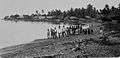 Men and children on the beach (1930-1936)
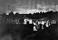 Fort de Verwachtingh in 1921
Sanana is located at 2°12′00″S 125°55′00″E / 2.2°S 125.916667°ECoordinates: 2°12′00″S 125°55′00″E / 2.2°S 125.916667°E, south of Mangole Island. The area of the island is 558 km².
Sanana airport is linked to Ambon by Trigana Air Service flights.[4]
As was common throughout Maluku at that time, Sanana suffered serious religio-ethnic tensions between Muslims and Christians during 1999.
References
| Wikimedia Commons has media related to Sanana. |
- ↑ Goodall, George (Editor)(1943) Philips' International Atlas London, George Philip and Son map 'East Indies' pp.91-92
- ↑ Lonely Planet guide to Indonesia 2010, page 741. Books.google.co.uk. Retrieved 2013-12-01.
- ↑ Photo of Sanana's fort before 1920
- ↑ "Trigana Air Service". Trigana-air.com. Retrieved 2013-12-01.
- ^ Ambon rioting leaves 100 dead in Indonesia from World Socialist Website, 30 January 1999
This article is issued from Wikipedia - version of the 11/17/2016. The text is available under the Creative Commons Attribution/Share Alike but additional terms may apply for the media files.