Sand Creek (Wyoming)
For other uses, see Sand Creek.
| Sand Creek[1] | |
|---|---|
 | |
| Basin | |
| Main source |
Laramie Mountains 40°49′46″N 105°47′04″W / 40.82944°N 105.78444°W[1]) |
| River mouth |
Confluence with Laramie 7,185 ft (2,190 m) 41°12′56″N 105°43′52″W / 41.21556°N 105.73111°WCoordinates: 41°12′56″N 105°43′52″W / 41.21556°N 105.73111°W |
| Features | |
| Designated | 1984 |
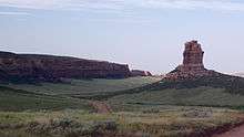
Sand Creek is a stream noted for the "most spectacular examples of cross-bedded sandstone and topple blocks in North America".[2] Sand Creek flows from the Laramie Mountains in Larimer County, Colorado into Albany County, Wyoming where it joins the Laramie River.[1]
The area where Sand Creek crosses the border between Colorado and Wyoming(40°59′49″N 105°46′14″W / 40.99694°N 105.77056°W) was designated a National Natural Landmark in 1984.[2]
See also
References
- 1 2 3 "Sand Creek". Geographic Names Information System. United States Geological Survey. Retrieved 2011-01-26.
- 1 2 "National Registry of Natural Landmarks" (PDF). National Park Service. June 2009. p. 109. Retrieved 2011-08-04.
External links
"Sand Creek National Natural Landmark". National Park Service.
This article is issued from Wikipedia - version of the 9/11/2016. The text is available under the Creative Commons Attribution/Share Alike but additional terms may apply for the media files.