Santa Ana de Velasco
| Santa Ana de Velasco | |
|---|---|
|
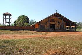
Mission church of Santa Ana de Velasco | |
 Santa Ana de Velasco Location in Bolivia | |
| Coordinates: 16°35′1″S 60°41′16″W / 16.58361°S 60.68778°WCoordinates: 16°35′1″S 60°41′16″W / 16.58361°S 60.68778°W | |
| Country |
|
| Department |
|
| Province | José Miguel de Velasco Province |
| Municipality | San Ignacio de Velasco Municipality |
| Elevation | 1,522 ft (464 m) |
| Population (2010)est. | |
| • Total | 684 |
Santa Ana de Velasco (or simply Santa Ana) is a small town in the Santa Cruz Department of the South American Andean Republic of Bolivia.
Location
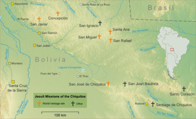
Santa Ana is the central town of Cantón Santa Ana and is located in the San Ignacio de Velasco Municipality, José Miguel de Velasco Province. It is known as part of the Jesuit Missions of the Chiquitos, which is declared in 1990 a World Heritage Site,[1] as a former Jesuit Reduction. The town is situated at an elevation of 464 m in the Chiqitanía region between Santa Cruz capital and the Brazilian border.
Regional traffic
Santa Ana is located 441 km north-east of Santa Cruz, the department's capital.
From there, the national road Ruta 4 goes north to Montero, Santa Cruz where it meets Ruta 10. This road goes east for 339 km to San Ignacio de Velasco, on its way passing San Ramón, San Javier and Santa Rosa de la Roca.
From San Igancio, a dirt road goes south to San Rafael de Velasco and passes Santa Ana after 45 km.
Population
The population of the place has increased rapidly over the past two decades:
- 1992: 284 inhabitants (census)[2]
- 2001: 483 inhabitants (census)[3]
- 2010: 684 inhabitants (updating)[4]
References
- ↑ World Heritage Site: Jesuit Missions of the Chiquitos
- ↑ Instituto Nacional de Estadística Bolivia (INE) 1992
- ↑ Instituto Nacional de Estadística Bolivia (INE) 2001
- ↑ World Gazetteer
External links
- Santa Ana de Velasco: Description of Jesuit mission with pictures and information
- Map of José Miguel de Velasco Province