Santa María Ahuacatitlán
| Santa María Ahuacatitlán | ||
|---|---|---|
| Village | ||
| ||
 | ||
|
Santa María Ahuacatitlán Location in Mexico | ||
| Coordinates: 18°52′N 99°15′W / 18.867°N 99.250°WCoordinates: 18°52′N 99°15′W / 18.867°N 99.250°W | ||
| Country |
| |
| State | Morelos | |
| Elevation | 1,650 m (5,410 ft) | |
| Population (2005) | ||
| • Total | 8,597 | |
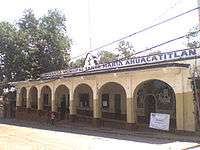
Santa Maria Ahuacatitlán is a village in the municipality of Cuernavaca, in the state of Morelos, Mexico. Ahuacatitlán means "place among aguacates" (avocados).
Location
Santa Maria Ahuacatitlán is located north of the city of Cuernavaca in Morelos. It borders Huitzilac and villages such as San Pedro Huertas to the north. On its eastern borders are the towns of Chamilpa and Ocotepec. In the south is Buena Vista and to the east Colonia del Bosque.
From Mexico City, the village can be reached by the Federal Mexico - Cuernavaca highway.
History
According to records of the city of Cuernavaca, Santa Maria Ahuacatitlan was formed when a portion of inhabitants of Cuernavaca fled the main city upon the approach of Hernán Cortés.
This article is issued from Wikipedia - version of the 9/17/2013. The text is available under the Creative Commons Attribution/Share Alike but additional terms may apply for the media files.