Santo António da Serra (Santa Cruz)
| Santo António da Serra | |
| Civil Parish | |
| Official name: Freguesia de Santo António da Serra | |
| Country | |
|---|---|
| Autonomous Region | |
| Island | Madeira |
| Municipality | Santa Cruz |
| Localities | João Ferino, Pereira, Madre d'Água, Curral Velho, Ribeira de João Gonçalves, Achada do Barro, Fajã da Ovelha, Serrado das Amexieiras |
| Center | Santo António da Serra |
| - coordinates | 32°43′N 16°49′W / 32.717°N 16.817°WCoordinates: 32°43′N 16°49′W / 32.717°N 16.817°W |
| Highest point | |
| - elevation | 667 m (2,188 ft) |
| Area | 14.75 km2 (6 sq mi) |
| Population | 936 (2011) |
| Density | 63/km2 (163/sq mi) |
| LAU | Junta Freguesia |
| - location | Estrada Santo António da Serra |
| President Junta | José António Baptista Reis |
| Timezone | WET (UTC0) |
| - summer (DST) | WEST (UTC+1) |
| Postal Zone | 9100-268 |
| Area Code & Prefix | (+351) 291 XX XX XX |
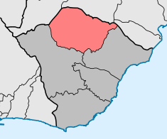 Location of the civil parish seat of Santo António da Serra in the municipality of Santa Cruz, island of Madeira | |
| Website: http://www.jfsantoantoniodaserra.ifreg.pt/ | |
Santo António da Serra is a civil parish in the municipality of Santa Cruz in the Portuguese autonomous region of Madeira. The parish is adjacent to another parish in the neighbouring municipality of Machico to the north, which is also named Santo António da Serra. The population in 2011 was 936,[1] in an area of 14.75 km².[2]
Geography
It is located west of Machico and east-northeast of the regional capital of Funchal.
References
This article is issued from Wikipedia - version of the 6/24/2014. The text is available under the Creative Commons Attribution/Share Alike but additional terms may apply for the media files.