Sawi District
| Sawi สวี | |
|---|---|
| Amphoe | |
 Amphoe location in Chumphon Province | |
| Coordinates: 10°15′11″N 99°5′40″E / 10.25306°N 99.09444°ECoordinates: 10°15′11″N 99°5′40″E / 10.25306°N 99.09444°E | |
| Country |
|
| Province | Chumphon |
| Seat | Sawi |
| Area | |
| • Total | 898.0 km2 (346.7 sq mi) |
| Population (2005) | |
| • Total | 69,340 |
| • Density | 77.2/km2 (200/sq mi) |
| Time zone | THA (UTC+7) |
| Postal code | 86130 |
| Geocode | 8607 |
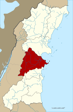
Sawi (Thai: สวี, pronounced [sā.wǐː]) is a district (Amphoe) in the central part of Chumphon Province, southern Thailand.
Geography
Neighboring districts are (from the south clockwise) Thung Tako, Lang Suan of Chumphon Province, La-un, Kra Buri of Ranong Province and Mueang Chumphon of Chumphon Province again. To the east is the Gulf of Thailand.
History
The districts goes back to the Mueang Sawi, located at shore of the Sawi river. On April 16 1897 a first district office was opened in village 5 of tambon Na Pho. After several relocations the present office in village 4 of tambon Sawi was opened on October 1 2001.
Administration
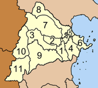
The district is subdivided into 11 subdistricts (tambon), which are further subdivided into 114 villages (muban). Na Pho is a township (thesaban tambon) which covers parts of the same-named tambon. There are further 10 Tambon administrative organizations (TAO).
|
 |