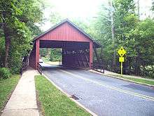
Scarborough Bridge
| Scarborough Bridge | |
|---|---|
 | |
| Coordinates | 39°54′02″N 74°59′33″W / 39.900667°N 74.992547°WCoordinates: 39°54′02″N 74°59′33″W / 39.900667°N 74.992547°W |
| Carries | 2 lanes of Covered Bridge Road |
| Crosses | North Branch of the Cooper River |
| Locale | Cherry Hill, New Jersey |
| Characteristics | |
| Total length | 55 feet |
| Width | 20 feet |
| Clearance above | 12 feet, 6 inches |
| History | |
| Designer | Malcolm Wells |
| Opened | February 14, 1959 |
The Scarborough Bridge is a wooden covered bridge in the Barclay Farms neighborhood of Cherry Hill, New Jersey. It carries 2 lanes of Covered Bridge Road (the bridge's namesake), as well as 2 sidewalks for pedestrians and bicyclists. The bridge was named after Bob Scarborough, a housing developer who established the Barclay Farms neighborhood, where the bridge is located. A bridge was needed in the area to extend the subdivision street system over the North Branch, which is a small tributary of the Cooper River. The bridge was designed by Malcolm Wells and was open to traffic on February 14, 1959.[1] The bridge was renovated in 1993.[2] Having a town truss design, the Scarborough Bridge is considered a historical landmark for the community.
References
- ↑ "Scarborough Covered Bridge Celebrates 50th Anniversary". Cherryhill-nj.com. Archived from the original on December 29, 2008. Retrieved December 26, 2011.
- ↑ Dr. Roger A. McCain. "Scarborough Bridge". faculty.lebow.drexel.edu. Archived from the original on April 29, 2011. Retrieved May 17, 2011.