Scharwoude, Koggenland
| Scharwoude | |
|---|---|
| Town | |
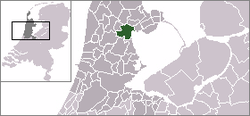 | |
 The town centre (dark green) and the statistical district (light green) of Scharwoude in the municipality of Wester-Koggenland. | |
| Coordinates: 52°37′N 5°1′E / 52.617°N 5.017°ECoordinates: 52°37′N 5°1′E / 52.617°N 5.017°E | |
| Country | Netherlands |
| Province | North Holland |
| Municipality | Koggenland |
| Population | |
| • Total | 490 |
| Time zone | CET (UTC+1) |
| • Summer (DST) | CEST (UTC+2) |

Scharwoude, church
Scharwoude is a town in the Dutch province of North Holland. It is a part of the municipality of Koggenland, and lies about 5 km southwest of Hoorn.
In 2001, the town of Scharwoude had 293 inhabitants. The built-up area of the town was 0.051 km², and contained 141 residences.[1] The statistical area "Scharwoude", which also can include the peripheral parts of the village, as well as the surrounding countryside, has a population of around 500.[2]
References
- ↑ Statistics Netherlands (CBS), Bevolkingskernen in Nederland 2001. (Statistics are for the continuous built-up area).
- ↑ Statistics Netherlands (CBS), Statline: Kerncijfers wijken en buurten 2003-2005. As of 1 January 2005.
This article is issued from Wikipedia - version of the 9/11/2015. The text is available under the Creative Commons Attribution/Share Alike but additional terms may apply for the media files.