Schlat
| Schlat | ||
|---|---|---|
| ||
 Schlat | ||
Location of Schlat within Göppingen district 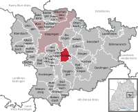
 | ||
| Coordinates: 48°39′9″N 9°42′28″E / 48.65250°N 9.70778°ECoordinates: 48°39′9″N 9°42′28″E / 48.65250°N 9.70778°E | ||
| Country | Germany | |
| State | Baden-Württemberg | |
| Admin. region | Stuttgart | |
| District | Göppingen | |
| Government | ||
| • Mayor | Gudrun Flogaus | |
| Area | ||
| • Total | 9.68 km2 (3.74 sq mi) | |
| Population (2015-12-31)[1] | ||
| • Total | 1,682 | |
| • Density | 170/km2 (450/sq mi) | |
| Time zone | CET/CEST (UTC+1/+2) | |
| Postal codes | 73114 | |
| Dialling codes | 07161 | |
| Vehicle registration | GP | |
| Website | www.schlat.de | |

Schlat is a municipality in the district of Göppingen in Baden-Württemberg in southern Germany.
Schlat in Göppingen district
History
Several grave mounds around suggest a first settlement during the Iron Age. Schlat was mentioned for the first time in 1139.
Buildings
The Andreaskirche was built in 1472 at the highest point of Schlat; it is dedicated to Andrew the Apostle. The church was renovated in 1999. A special feature of the church is the sharing between the Catholic and the Protestant parish.
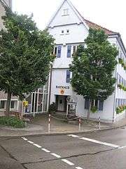
Town hall in Schlat district Göppingen Baden-Württemberg
Schlat Göppingen district center
Sons and daughters of the town
John Mühlhäuser (1834-1914), viticulture specialist, Member of Landtag 1870-1876
| Wikimedia Commons has media related to Schlat. |
References
This article is issued from Wikipedia - version of the 10/2/2016. The text is available under the Creative Commons Attribution/Share Alike but additional terms may apply for the media files.