Schweiggers
| Schweiggers | ||
|---|---|---|
| ||
 Schweiggers Location within Austria | ||
| Coordinates: 48°40′00″N 15°03′00″E / 48.66667°N 15.05000°ECoordinates: 48°40′00″N 15°03′00″E / 48.66667°N 15.05000°E | ||
| Country | Austria | |
| State | Lower Austria | |
| District | Zwettl | |
| Government | ||
| • Mayor | Johann Hölzl (ÖVP) | |
| Area | ||
| • Total | 58.65 km2 (22.64 sq mi) | |
| Elevation | 633 m (2,077 ft) | |
| Population (1 January 2016)[1] | ||
| • Total | 1,993 | |
| • Density | 34/km2 (88/sq mi) | |
| Time zone | CET (UTC+1) | |
| • Summer (DST) | CEST (UTC+2) | |
| Postal code | 3931 | |
| Area code | 02829 | |
| Vehicle registration | ZT | |
| Website | www.schweiggers.gv.at | |
Schweiggers is a municipality in the district of Zwettl, in Lower Austria, Austria.
History
The municipality shares the changeful History of Austria.
1182: First mention as "Swichers".
1643: The name "Schweiggers" appears.
Landscape
The landscape of Schweiggers is characterized by gentle hills and green valleys.
River
The origin of the German Thaya river is near Schweiggers.
Population
| Historical population | ||
|---|---|---|
| Year | Pop. | ±% |
| 1971 | 2,162 | — |
| 1981 | 2,127 | −1.6% |
| 1991 | 2,067 | −2.8% |
| 2001 | 2,039 | −1.4% |
| 2013 | 1,986 | −2.6% |
Coat of arms
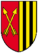
The coat of arms is divided in two. The left side shows two crossed arrows on a red background, and the right side shows two black stanchions on a golden background. The right side reminds of the coat of arms of the Kuenringer, an Austrian dynasty.
References
External links
| Wikimedia Commons has media related to Schweiggers. |
This article is issued from Wikipedia - version of the 12/13/2014. The text is available under the Creative Commons Attribution/Share Alike but additional terms may apply for the media files.