Scotswood Railway Bridge
| Scotswood Railway Bridge | |
|---|---|
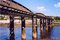 Scotswood Railway Bridge viewed from the south east on 25 August 2005 | |
| Carries |
Water mains Gas mains formerly Railway |
| Crosses | River Tyne |
| Locale | Tyne and Wear, England |
| Characteristics | |
| Design | Hog-back bridge |
| Total length | 212.6 m (698 ft) |
| Width | 7.7 m (25 ft) |
| History | |
| Construction end | 1871 |
| Opened | 1871 |
The Scotswood Railway Bridge is a disused railway bridge crossing the River Tyne in North East England, formerly part of the Newcastle and Carlisle Railway, carrying the main line between the Scotswood and Blaydon stations.
History
The first railway bridge across the River Tyne at this location was a timber bridge completed in 1839. This was destroyed by fire caused by hot ash from a passing train in 1860. A wooden replacement opened in 1861 which was then replaced by a temporary single track bridge in 1865.
The current bridge
The fourth bridge on this site was opened in 1871[1] and cost £20,000 to build. It is a six-span wrought-iron hog-back bridge on five cast-iron cylinder piers. It was set at an angle to the river so that trains could approach the bridge at speed, there being no sharp curve onto the bridge. It required strengthening in 1943.[2] It was taken out of use permanently in November 1982, when the trains on the N&CR were re-routed across the King Edward VII Bridge and through Dunston. Goods trains continued to use the line on the north side of the Tyne up until around 1990, taking coal to the Stella North Power Station and materials to the Ever Ready battery factory at Newburn.
The bridge is still used to carry water and gas mains over the river but the railway tracks have been removed and it is no longer possible to cross safely.[3]
References
| Next rail crossing upstream | River Tyne | Next rail crossing downstream |
| Wylam Railway Bridge (disused, now foot and bicycle) |
Scotswood Railway Bridge (disused rail, now carries water and gas mains) Grid reference: NZ196638 |
King Edward VII Bridge |
| Next road crossing upstream | River Tyne | Next road crossing downstream |
| Blaydon Bridge (A1 road) |
Scotswood Railway Bridge (disused rail, Grid reference: NZ196638 |
Scotswood Bridge |
Coordinates: 54°58′05″N 1°41′38″W / 54.968°N 1.694°W