Scotts Flat Reservoir
| Scotts Flat Reservoir | |
|---|---|
 | |
| Location |
Tahoe National Forest Nevada County, California |
| Coordinates | 39°16′22″N 120°55′50″W / 39.2727°N 120.9305°WCoordinates: 39°16′22″N 120°55′50″W / 39.2727°N 120.9305°W |
| Type | Reservoir |
| Primary inflows | Deer Creek |
| Primary outflows | Deer Creek |
| Basin countries | United States |
| Surface area | 850 acres (340 ha) |
| Surface elevation | 936 m (3,071 ft) |
| Settlements | Scotts Flat Lake |
| References | U.S. Geological Survey Geographic Names Information System: Scotts Flat Reservoir |
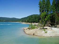
Scotts Flat Reservoir is an artificial lake in the Tahoe National Forest of Nevada County, California, 6.5 miles (10.5 km) east of Nevada City. The lake is at an elevation of 3,100 ft (940 m) and has a surface area of 850 acres (340 ha), with 7.5 miles (12.1 km) of shoreline lined with pine trees. Amenities consist of two launch ramps, a marina, campsites, a picnic area, sandy beaches, and a general store.[1][2]
The earthen rock-fill Scotts Flat Dam dates from 1948 and impounds Deer Creek to create the reservoir with a capacity of 49,000 acre-feet. At 175 feet above streambed, the dam is owned and operated by the county-level Nevada Irrigation District.[3]
See also
References
- ↑ http://www.campingfriend.com/ScottsFlatLakeRecArea/default.asp?source=ctpa&strExchange= Camp California - Scotts Flat Lake
- ↑ http://www.scottsflatlake.net/html/amenities.html Scotts Flat Lake Amenities
- ↑ http://findlakes.com/scotts_flat_california~ca00253.htm
External links
This article is issued from Wikipedia - version of the 2/21/2016. The text is available under the Creative Commons Attribution/Share Alike but additional terms may apply for the media files.