Scoudouc, New Brunswick
| Scoudouc | |
|---|---|
| Village | |
|
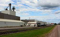
Former Owens-Illinois glass plant in Scoudouc, New Brunswick. It was constructed in an aircraft hangar, part of an abandoned World War II air base. O-I was the latest in a long list of owners of the glass manufacturing plant. | |
 Scoudouc The location of Scoudouc within New Brunswick. | |
| Coordinates: 46°10′07″N 64°33′45″W / 46.168657°N 64.562616°WCoordinates: 46°10′07″N 64°33′45″W / 46.168657°N 64.562616°W | |
| Country |
|
| Province | New Brunswick |
| County | Westmorland County |
| Parish | Shediac Parish |
| Metropolitan areas of New Brunswick | Greater Shediac |
| Founded | 1898 |
| Government | |
| • Governing Body | Scoudouc Village Council |
| Area | |
| • Total | 2.00 km2 (0.77 sq mi) |
| Population (2011) | |
| • Total | 200 |
| • Density | 464.9/km2 (1,204/sq mi) |
| Time zone | AST (UTC−4) |
| • Summer (DST) | ADT (UTC−3) |
| Area code(s) | 506 |
| Highways |
|
History
Located near Scoudouc River, 6.13 km SSW of Shediac: Shediac Parish, Westmorland County: William Francis Ganong identified the Mi'kmaq name for Scoudouc River as Oumskoodook: PO Scadouc 1890-1932: in 1898 "Scadouc" was a farming and lumbering settlement with 1 store, 1 sawmill, 1 church and a population of about 200: also called Bellevue Settlement: included the community of Dorchester Crossing: PO from 1885: in 1898 Dorchester Crossing was a farming and lumbering settlement with 1 post office, 1 sawmill, 1 grist mill and a population of 250: PO Scoudouc 1932-1961.[1]
Places of note
- Scoudouc Industrial Park.[2]
Notable people
Main article: List of people from Westmorland County, New Brunswick
See also
Bordering communities
 |
Shediac | Shediac | Barachois | |
| Lakeville | |
Bourgeois Mills | ||
| ||||
| | ||||
| Painsec Junction | Meadow Brook | Basse-Aboujagane |
References
- ↑ Details of Scoudouc History, Government of Canada.
- ↑ Scoudouc Industrial Park Poised for Growth, Greater Moncton.
This article is issued from Wikipedia - version of the 10/14/2016. The text is available under the Creative Commons Attribution/Share Alike but additional terms may apply for the media files.