Scribner Covered Bridge
| Scribner Covered Bridge | |
|---|---|
 Bridge in U.S. state of Vermont | |
| Carries | Automobile |
| Crosses | Gihon River |
| Locale | Johnson, Vermont |
| Maintained by | Town of Johnson |
| ID number | VT-08-09 |
| Characteristics | |
| Design | Covered, Queen post |
| Material | Wood |
| Total length | 47.8 ft (14.57 m) |
| Width | 12.4 ft (3.78 m) |
| Number of spans | 1 |
| Load limit | 8 tons |
| Clearance above | 8.25 ft (2.51 m) |
| History | |
| Constructed by | unknown |
| Construction end |
unknown |
|
Scribner Covered Bridge | |
  | |
| Coordinates | 44°38′17″N 72°38′53″W / 44.63806°N 72.64806°WCoordinates: 44°38′17″N 72°38′53″W / 44.63806°N 72.64806°W |
| Area | 1 acre (0.4 ha) |
| NRHP Reference # | 74000233[1] |
| Added to NRHP | October 1, 1974 |
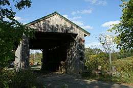
The Scribner Covered Bridge, also known as the Mudgett Covered Bridge,[2] is a covered bridge that crosses the Gihon River off State Route 100C in Johnson, Vermont. It was listed on the National Register of Historic Places in 1974.[1]
The bridge is of Queen post truss design by an unknown builder. It has been determined that the bridge was originally an uncovered Pony truss bridge, due to the relatively low height of the queen post trusses and the discovery of historical documents.[3]
Recent history
In 1960, minor repairs were carried out and steel I beams were installed underneath the road deck.[3]
References
- 1 2 National Park Service (2010-07-09). "National Register Information System". National Register of Historic Places. National Park Service.
- ↑ U.S. Geological Survey Geographic Names Information System: Scribner Covered Bridge
- 1 2 Barna, Ed. Covered Bridges of Vermont. The Countryman Press, 1996. ISBN 0-88150-373-8
This article is issued from Wikipedia - version of the 11/28/2016. The text is available under the Creative Commons Attribution/Share Alike but additional terms may apply for the media files.