Selenter See
| Selenter See | |
|---|---|
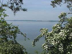 The lake near Selent | |
| Location | Schleswig-Holstein |
| Coordinates | 54°18′20″N 10°26′43″E / 54.30556°N 10.44528°ECoordinates: 54°18′20″N 10°26′43″E / 54.30556°N 10.44528°E |
| Primary outflows | Mühlenau, Salzau |
| Basin countries | Germany |
| Surface area | 22.4 km2 (8.6 sq mi) |
| Average depth | 34 m (112 ft) |
| Surface elevation | 37 m (121 ft) |
| Settlements | Selent |
The Selenter See is the second-largest lake in the North German state of Schleswig-Holstein, after the Großer Plöner See. It lies at an elevation of 37 m above sea level (NN) and has an area of 22.4 km².
The Selenter See, which lies near the village of Selent in the district of Plön, is 34 m deep. The lake drains into the Baltic Sea through the Hohenfelder Mühlenau, only 10 km long, to the north and by the Salzau to the northwest.
The formation of the Selenter See goes back to the ice sheets of the Weichselian glaciation, which hollowed out a basin and simultaneously formed ridges of terminal moraine up to 132 m high in the east and 90 m high in the south. From a geological point of view the lake is a so-called "tongue basin lake" or Zungenbeckensee.
The lake is well-known inter alia for plentiful supply of fish such as eel, perch, pike, and large and small whitefish and large quantities of roach.
Bird reserve
There is a 3,060 hectares (7,600 acres) bird reserve called the Selenter See-Gebiet which covers the lake and its bordering reed beds and carr areas as well as the Gottesgabe Wood. It is an important breeding, moulting and resting area for numerous birds including the kingfisher, bittern, whooper swan, goosander, great crested grebe, crane and sea eagle. The reserve is managed by a charitable organisation, the LLUR.[1]
See also
References
- ↑ LLUR überträgt ehrenamtliche Betreuung für EG-Vogelschutzgebiet "Selenter See-Gebiet". Accessed on 21 Aug 2010,
External links
- Nixdorf, B.; et al. (2004), "Selenter See" (PDF), Dokumentation von Zustand und Entwicklung der wichtigsten Seen Deutschlands (in German), Berlin: Umweltbundesamt, p. 82
- Hydrobiological studies of four small streams in Schleswig-Holstein (Salzau, Hatener Au, Kossau and Osterau) at www.schriften.uni-kiel.de (University of Kiel). (German)
| Wikimedia Commons has media related to Selenter See. |