Selfridge AFB radar station
| Selfridge AFB radar station | |
| call sign: Silvia | |
| USAF General Surveillance Radar Station | |
| Country | United States |
|---|---|
| State | Michigan |
| Command | Aerospace Defense Command |
| Location | point east of radar tower |
| - coordinates | 42°37′40.5″N 82°49′45.1″W / 42.627917°N 82.829194°W [1] |
| Annexes | Gap Filler radar sites |
| - P-20A Burnside MI | 43°10′53″N 083°03′11″W / 43.18139°N 83.05306°W |
| - P-20B Emery MI | 42°22′00″N 083°39′42″W / 42.36667°N 83.66167°W |
| - P-20C Marblehead OH | 41°32′21″N 082°44′26″W / 41.53917°N 82.74056°W |
|
| |
|
| |
|
|
| Selfridge AFB Army Air Defense Command Post | |
| Army command and control facility | |
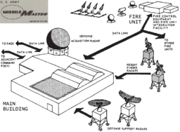 The Selfridge AADCP networked local radars (middle, bottom) and directed Michigan's Nike fire units--each with a network of 3 radars (top) for acquiring the target, tracking the target, and tracking/guiding the Nike missile. | |
| Country | United States |
|---|---|
| State | Michigan |
| Region | Detroit Defense Area |
| Command | Army Air Defense Command |
| Parts | 1957: AN/FSG-1 1967: AN/TSQ-51[2]:136 |
| Location | Missile Master nuclear bunker |
| - coordinates | 42°37′37″N 82°49′47″W / 42.62694°N 82.82972°WCoordinates: 42°37′37″N 82°49′47″W / 42.62694°N 82.82972°W [3] |
The Selfridge AFB radar station began operations in 1949 with a Bendix AN/CPS-5 Radar test that tracked aircraft at 210 mi (340 km). A height finder MIT AN/CPS-4 Radar was added by March 9, 1950; and the station was site L-17 of the Lashup Radar Network and site LP-17 of the subsequent network during construction of the Air Defense Command permanent network. The 661st Aircraft Control and Warning Squadron was activated at Selfridge in 1951, and with a pair of General Electric AN/CPS-6 Radars the station became site LP-20 of the permanent ADC network in 1952. In 1957 the station added a height finder General Electric AN/FPS-6 Radar. The station became part of the Semi Automatic Ground Environment radar network in 1959, supplying radar tracks to SAGE data center DC-06 at Custer Air Force Station, Michigan, for directing interceptor aircraft and CIM-10 Bomarc air defense missiles.
By 1960, the AN/CPS-6 radar had been replaced by a Bendix AN/FPS-20 Radar for general surveillance, and the site had an additional General Electric AN/FPS-6A height-finder radar. A Sperry AN/FPS-35 radar installed at the station's tower in 1961 became operational in 1962, and the AN/FPS-6A height-finder was replaced with an Avco AN/FPS-26A Radar c. 1963. On 31 July 1963, Selfridge AFB was redesignated as NORAD site Z-20.
The 661st AC & WS also operated Gap Filler sites with Bendix AN/FPS-18 Radars before deactivating on July 1, 1974. The radar station was shared with the United States Army for Nike missile command-and-control.
In 1960, Army Air Defense Command Post (AADCP) D-15DC was constructed for coordinating Nike surface-to-air missile launches from numerous Michigan batteries from Algonac/Marine City (D-17) south to Carleton (D-57) & Newport (D-58). The AADCP closed when the Army deactivated the remaining D-06, D-58, & D-87 batteries in April 1974 at Utica, Newport, and Commerce/Union Lake.
The former radar station is the location of a United States Marine Corps Reserve unit and the Selfridge Military Air Museum & Air Park. The Missile Master bunker was subsequently used as a air traffic control centre[4] manned by the 2031st Communications Squadron.[5][6] Documents regarding the bunker, demolished in 2005, have been entered in the Historic American Engineering Record.[3][5]
References
- ↑ "Information for Selfridge AFB, MI". Air Defense Radar Stations. Radomes.org. Retrieved 2011-10-03.
- ↑ McMaster, B. N., et al (December 1984). Historical Overview of the Nike Missile System (PDF) (Report). Environmental Science and Engineering, Inc. Retrieved 2011-09-16.
NOTE: The sequence of July 1 maps in this report display successive marks for the Selfridge AADCP annually moving southward to the Michigan-Ohio border near Toledo. - 1 2 Bateman, Tom. "Site D-15DC - Selfridge AFB/ANGB". Detroit - Cleveland Defense Area. NikeHercules.Tripod.com. Retrieved 2011-09-16.
- ↑ [http://www.saffm.hq.af.mil/shared/media/document/AFD-090416-118.pdf RAPCON center
- 1 2 Selfridge Field, Building No. 1050… (Report). Library of Congress: Historic American Buildings Survey/Historic American Engineering Record. Retrieved 2011-09-27.
- ↑ 2031st and