Seulawah Agam
| Seulawah Agam | |
|---|---|
 Mount Seulawah Agam | |
| Highest point | |
| Elevation | 1,810 m (5,940 ft) [1] |
| Prominence | 1,610 m (5,280 ft) [2] |
| Listing |
Ultra Ribu |
| Coordinates | 05°26′51″N 95°39′21″E / 5.44750°N 95.65583°ECoordinates: 05°26′51″N 95°39′21″E / 5.44750°N 95.65583°E [2] |
| Geography | |
| Geology | |
| Mountain type | Stratovolcano |
| Last eruption | January 1839 |

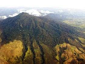
Seulawah Agam is an extensive forested stratovolcano located at the northwestern tip of Sumatra. Several names have been given to the mountain: Seulawaih Agam, Seulawain Agam, Solawa Agam, Solawaik Agam, Selawadjanten and Goldberg.[3]
The volcano was constructed during the Pleistocene-Holocene age.[1] The mountain has a large caldera, called Lam Teuba. A smaller 8×6 km caldera is within the Lam Teuba caldera. The volcano contains several hills: sedimentary hills, old volcano hills, a volcanic cone and peneplain area. The volcanic cone was formed by lava and pyroclastic flows.[3] There are three craters. The Tanah Cempago crater is easily recognized, while the other two are covered with vegetations.
As of January 2013, Seulawah Agam is showing signs of renewed activity. Localised seismicity has been recorded in the vicinity of the volcano.
See also
References
- 1 2 "Seulawah Agam". Global Volcanism Program. Smithsonian Institution. Retrieved 2006-11-30.
- 1 2 "Mountains of the Indonesian Archipelago". Peaklist.org. Retrieved 2013-08-18.
- 1 2 "Seulawah Agam Volcano, Indonesia". John Seach, an Australian volcanologist. Retrieved 2006-11-30.