Sha Lo Wan
.jpg)
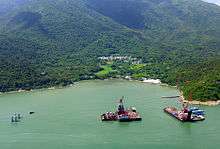
Sha Lo Wan (Chinese: 沙螺灣) is a bay in the northwest Lantau Island, Hong Kong. The bay faces north to Hong Kong International Airport. The area is occupied by indigenous inhabitants. There is no vehicular access to the area and thus their communication is on foot or by ferry.[1] Because of their inconvenient access to urban areas, villages in the area have suffered from depopulation. Only older generations live in these villages.
Villages in the area include Sha Lo Wan Tsuen (沙螺灣村; "Sha Lo Wan Village"), Sha Lo Wan San Tsuen (沙螺灣新村; "Sha Lo Wan New Village") and Sha Lo Wan Chung Hau (沙螺灣涌口).
History
Sha Lo Wan was noted for its incense production during the Ming dynasty.[2] Following the orders imposed by the Great Clearance, the village was evacuated, together with the whole of Lantau Island. People were allowed to return to settle on the island in 1669, but Sha Lo Wan was not resettled at that time.[3]
Sha Lo Wan Tsuen was probably erected in the 18th century, as a Ba Kong Temple (把港古廟; "guarding the bay") dedicated to Hung Shing was built by the villagers in 1774 at the northwest of the village, close to the seashore. Villagers were engaged in fishing and farming. The population was small reaching up to a few hundreds before the Second World War. Being close to the sea, the village was often attacked by pirates and bandits. In the late 1930s, it was occupied by a group of pirates for one year.[4]
Tungsten was discovered in Sha Lo Wan, and its ore was quarried in the area in the 1950s, leading to a population increase, which reached 4,000 in 1971. The population has dropped again since the 1970s.[4]
Features
The bay is a preserved tropical natural environment. Thick and high trunks of trees can be found in the area.
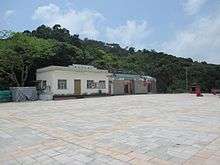
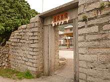
Sha Lo Wan Tsuen was constructed in the form of four parallel rows of houses. A 3m high village entrance gate, built about 200 years ago of granite blocks and slabs, remains in the north of the village, while the attached defensive wall has been demolished.[4] There are three ancestral halls in the village.[5]
Two adjacent temples are located at Sha Lo Wan, near the coast. The Ba Kong Temple, dedicated to Hung Shing, was built in 1774.[6] To its right is a Tin Hau Temple, built in 1919. A wall is connecting the two temples at the front façade.[7] They are sometimes collectively referred to as "Pa Kong Ancient Temple and Tin Hau Palace" (把港古廟及天后宮).[8]
Besides the small Sha Lo Wan Playground, the village only other attraction is Tung Chung Sha Lo Wan Beach.
Access
By Foot
Sha Lo Wan is situated on the trail from Tai O to Tung Chung, known as the Tung O Ancient Trail (東澳古道) that heads east along Tung Chung Bay.
Other
There is no vehicular access to the area, but the construction of a road linking Tai O and Tung Chung, and serving Sha Lo Wan, has been proposed in 2014.[1]
The area is served by ferries operated by Fortune Ferry[9] to Tung Chung, Tai O and Tuen Mun at the end of Sha Lo Wan Pier.
References
- 1 2 Lantau Development Advisory Committee: Construction of an East-West Coastal Road in North Lantau (proposal), November 2014
- ↑ 蕭, 國健 (May 1990). 香港前代社會 'The Society of Hong Kong of Previous Dynasties' (in Chinese) (2nd ed.). Hong Kong: Zhonghua Book Company. p. 67. ISBN 962-231-744-8.
- ↑ Siu, Anthony Kwok-kin (1989). "Tai Yu Shan from Chinese Historical Records" (PDF). Journal of the Royal Asiatic Society Hong Kong Branch. 29: 396. ISSN 1991-7295. Retrieved October 24, 2014.
- 1 2 3 Brief Information on Proposed Grade III Items. Item #1151
- ↑ Cultural Heritage Impact Assessment, July 2009
- ↑ Brief Information on No Grade Items, pp.263-264
- ↑ Brief Information on No Grade Items, pp.229-230
- ↑ Chinese Temples Committee: Pa Kong Ancient Temple & Tin Hau Palace
- ↑ Fortune Ferry timetable
Further reading
- Hamilton, Eric; Schofield, Walter; Peplow, S. H.; Tsui, Paul; Coates, Austin; Hayes, James (2010). "Lantao North Coast: Tai O to Tung Chung". In Strickland, John. Southern District Officer Reports: Islands and Villages in Rural Hong Kong, 1910-60. Hong Kong University Press. pp. 65–68. ISBN 9789888028382.
External links
| Wikimedia Commons has media related to Sha Lo Wan. |
- Hung Shing Festival in Sha Lo Wan (Chinese)
- Archaeological Survey Report at Sha Lo Wan (West) Southern Headland (march 2007)
- Picture of Sha Lo Wan Pier
Coordinates: 22°17′15″N 113°54′07″E / 22.287568°N 113.901873°E