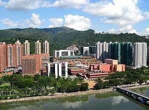
Sha Tin New Town
| Shatin New Town 沙田新市鎮 | |
|---|---|
| Nickname(s): Sha Tin | |
| Country |
|
| Region | New Territories |
| District | Sha Tin District |
| Area | |
| • City | 35.87 km2 (13.85 sq mi) |
| Population (2010) | |
| • City | 630,000 |
| • Urban | 630,000 |
| Time zone | Hong Kong Time (UTC+8) |
| Mean solar time UTC+08 | |
| Sha Tin New Town | |||||||
 The town centre of Shatin New Town | |||||||
| Traditional Chinese | 沙田新市鎮 | ||||||
|---|---|---|---|---|---|---|---|
| |||||||
Shatin New Town is one of the new towns in Hong Kong. It is within the Sha Tin District, which covers the areas of Sha Tin, Tai Wai, Fo Tan, Tai Shui Hang, Ma On Shan, among other areas, and is near the Shing Mun River.
Development started in the 1970s, and currently covers an area of 35.87 square kilometres with total developed area of about 20 km². Presently it has a population over 630,000 with a planned capacity when fully developed of 735,000.[1] The town centre houses a mall, New Town Plaza, the Sha Tin Public Library, a town hall, and other community facilities.
In the latest official reports, Ma On Shan New Town, a satellite extension of Shatin will form a separate distinct from Sha Tin.
Transport
Highways, roads and tunnels
The road transport between Shatin and Kowloon relies on Lion Rock Tunnel, Tate’s Cairn Tunnel, Shing Mun Tunnel and Tai Po Road. The Tolo Highway was opened in September 1985. It connected Sha Tin Road and Tai Po Road, forming a connection system between the New Town and Tai Po. Tate’s Cairn Highway also connected Ma On Shan with Tolo Highway as well. The opening of Sai Sha Road in October 1988 provided a connection between Sha Tin and Sai Kung. The T3 Highway (Tsing Sha Highway) and Route No.8 Cheung Sha Wan to Sha Tin Section was completed in March 2008.
Public transport
The New Town has numerous bus routes connecting to the city centre and railway station from various populated zone in the Town. Beside bus services, minibus services are provided as well for residential area with fewer people.
KCR (now East Rail Line, MTR)
KCR, since merged with the former MTR, was essential to the development of new town. There are five East Rail Line stations within the new town, namely Tai Wai, Sha Tin, Fo Tan, Racecourse and University (Chinese University). The whole section of Ma On Shan Line lies within the district, which connects Tai Wai and Wu Kai Sha of Ma On Shan (situated at the northeastern part of Lee On Estate). It has a length of 11.4 km with nine stations and one maintenance centre. Passengers can transfer to East Rail Line at Tai Wai Station.
External links
- Sha Tin New Town
- Jeffrey W. Cody and James R. Richardson (1997). "Urbanizing forest and Village Trees in Hong Kong's Sha Tin Valley, 1976-1997" (PDF). Traditional Dwellings and Settlements Review. IX (1): 21–33.
References
- ↑ Civil Engineering and Development Department: Sha Tin New Town. Accessed on 2013-04-21.
Coordinates: 22°22′49″N 114°11′23″E / 22.380238°N 114.189835°E