Shaldon
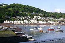

Shaldon is a village and civil parish in South Devon, England. It is located on the south bank of the estuary of the River Teign, opposite the town of Teignmouth. The village has been described as "a quaint English drinking village, with a fishing problem";[1] it is a popular bathing place and is characterised by Georgian architecture.
In the 2011 Census, the parish had a population of 1,762. Its northern boundary follows the Teign estuary and its eastern boundary is the English Channel. It has a short boundary with the unitary authority of Torbay to the south, and its eastern border is with the parish of Stokeinteignhead.[2] The village is a major part of the electoral ward called Shaldon and Stokeinteignhead with a population in 2011 of 2,465.[3]
History
Shaldon was located in the hundred of Wonford. The original river settlement was upstream in Ringmore where the valley was farmed and the inhabitants were hidden from the sea. Up to the beginning of the 20th Century Ringmore had many working farms, extensive apple and other orchards, including cider apples, watercress beds, and withy beds used for making lobster pots. There were also shipbuilding and repair yards on the waterfront.
Shaldon itself is built on reclaimed land and there is a retaining wall, built around 1800, to prevent the river returning to its beaches.
Local government
Shaldon is part of Teignbridge local government district, which was created in 1974 under the Local Government Act 1972. The village had previously been in St Nicholas Parish. The parish contained Shaldon and part of the adjacent village of Ringmore, and became part of Teignmouth Urban District in 1881.[4][5]
Regatta
The Shaldon regatta is one of the oldest in England dating back to at least 1817, if not before. The modern regatta runs for 9 days each August.
Homeyards Botanical Gardens
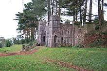
On a hillside above the village are gardens created by Maria 'Laetitia' Kempe Homeyard in the late 1920s and early 1930s and built by Thomas Rider, consisting of an informal terraced arboretum with a level walk along the top providing views of the Teign estuary and the Jurassic Coast. A feature of the gardens is a folly known as Shaldon Castle. First opened to the public in 1955 and currently under the stewardship of Teignbridge District Council, the gardens are open all year round.
References
- ↑ Law, Cally (30 July 2006). "Smooth Sailing". Times Online. Times Newspapers. Retrieved 19 June 2008.
- ↑ "Map of Devon Parishes" (PDF). Devon County Council. Retrieved 20 June 2013.
- ↑ "Ward population 2011". Retrieved 18 February 2015.
- ↑ "Devon Libraries Local Studies Service: Shaldon community page". Devon County Council. 22 February 2005. Retrieved 19 June 2008.
- ↑ "GENUKI/Devon: Shaldon - Genealogy". GENUKI. 29 April 2008. Retrieved 19 June 2008.
External links
| Wikimedia Commons has media related to Shaldon. |
Coordinates: 50°32′25″N 3°30′18″W / 50.5402°N 3.505°W