Shepparton Airport
| Shepparton Airport | |||||||||||||||
|---|---|---|---|---|---|---|---|---|---|---|---|---|---|---|---|
 | |||||||||||||||
| IATA: SHT – ICAO: YSHT | |||||||||||||||
| Summary | |||||||||||||||
| Airport type | Public | ||||||||||||||
| Operator | Greater Shepparton City Council | ||||||||||||||
| Location | Shepparton, Victoria | ||||||||||||||
| Elevation AMSL | 374 ft / 114 m | ||||||||||||||
| Coordinates | 36°25′44″S 145°23′33″E / 36.42889°S 145.39250°ECoordinates: 36°25′44″S 145°23′33″E / 36.42889°S 145.39250°E | ||||||||||||||
| Map | |||||||||||||||
 YSHT Location in Victoria | |||||||||||||||
| Runways | |||||||||||||||
| |||||||||||||||
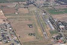
Shepparton Airport (IATA: SHT, ICAO: YSHT) is located south of Shepparton, Victoria, Australia on the Goulburn Valley Highway.
See also
References
- ↑ YSHT – Shepparton (PDF). AIP En Route Supplement from Airservices Australia, effective 10 November 2016, Aeronautical Chart
This article is issued from Wikipedia - version of the 12/4/2016. The text is available under the Creative Commons Attribution/Share Alike but additional terms may apply for the media files.