Sierra de la Giganta
| Sierra de la Giganta | |
|---|---|
|
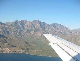
Eastern face, seen from the Gulf of California | |
| Highest point | |
| Peak | Cerro de la Giganta |
| Elevation | 3,858 ft (1,176 m) |
| Geography | |
| Country | Mexico |
| State | Baja California Sur |
| Municipality | La Paz Municipality and Loreto Municipality |
The Sierra de la Giganta is a mountain range of eastern Baja California Sur state, located on the southern Baja California Peninsula in northwestern Mexico.
It is a mountain range of the Peninsular Ranges System, which extends 1,500 km (930 mi) from Southern California, through the Baja California Peninsula in Baja California and Baja California Sur states.
Geography
The Sierra de la Giganta extends along the southeastern Baja California Peninsula, parallel and close to the coast of the Gulf of California—Sea of Cortez. The highest point is Cerro de la Giganta at 3,858 feet (1,176 m) in elevation, located near Loreto
The range runs from Loreto in Loreto Municipality west of Loreto, southwards to La Paz Municipality northwest of La Paz.[1]
- Natural history
The xeric flora found in the Sierra de la Giganta is of the Baja California Desert ecoregion, of the Deserts and xeric shrublands Biome.
See also
- Flora of Baja California Sur
- Peninsular Ranges topics
References
- ↑ Albert W. Bally; Allison R. Palmer (1989). Geology of North America—An Overview. Geological Society of America. pp. 245–. ISBN 978-0-8137-5445-1.
External links
Coordinates: 26°11′N 111°37′W / 26.19°N 111.61°W