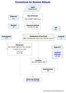
Sight reduction
Sight reduction is the process of deriving from a sight the information needed for establishing a line of position.
Sight is defined as the observation of the altitude, and sometimes also the azimuth, of a celestial body for a line of position; or the data obtained by such observation.[1]
Nowadays sight reduction uses the equation of the circle of equal altitude to calculate the altitude of the celestial body,

and the azimuth Zn is obtained from Z by:

With the observed altitude Ho, Hc and Zn are the parameters of the Marcq St Hilaire intercept for the line of position:
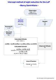
With B the latitude (+N/S), L the longitude (+E/-W), LHA = GHA + L is the local hour angle, Dec and GHA are the declination and Greenwich hour angle of the star observed, and Hc the calculated altitude. Z is the calculated azimuth of the body.
Basic procedures involved computer sight reduction or longhand tabular methods.
Tabular sight reduction
The methods included are:
- The Nautical Almanac Concise method (NASR)
- Pub. 249 (formerly H.O. 249, Sight Reduction Tables for Air Navigation, A.P. 3270 in the UK)
- Pub. 229 (formerly H.O. 229, Sight Reduction Tables for Marine Navigation
- H.D. 486 (in the United Kingdom)
- H.O. 214 (Tables of Computed Altitude and Azimuth)
- H.O. 211 (Dead Reckoning Altitude and Azimuth Table, Third Edition, known as Ageton, and the Modified H.O. 211 Compact Sight Reduction Table, known as Ageton-Bayless)
- H.O. 208 (Navigation Tables for Mariners and Aviators, Sixth Edition, known as Dreisonstok)
- S-Table
Longhand haversine sight reduction
This method is a practical procedure to reduce celestial sights with the needed accuracy, without using electronic tools such as calculator or a computer. And it could serve as a backup in case of malfunction of the positioning system aboard.
Doniol
The first approach of a compact and concise method was published by R. Doniol in 1955[2] The altitude is derived from sin(Hc) = n − a (m + n), in which n = cos(B − Dec), m = cos(B + Dec), a = hav(LHA).
The calculation is:
n = cos(B - Dec)
m = cos(B + Dec)
a = hav(LHA)
sin_Hc = n - a (m + n)
Hc = arcsin(sin_Hc)
Ultra compact sight reduction

A practical and friendly method using haversines was developed between 2014 and 2015,[3] and published in NavList.
A compact expression for the altitude was derived[4] using haversines, hav, for all the terms of the equation:
hav(ZD) = hav(B - Dec) + (1 - hav(B - Dec) − hav(B + Dec)) hav(LHA)
where ZD is the zenith distance
Hc = (90 - ZD) the calculated altitude
The algorithm if absolute values are used is:
if same name for latitude and declination
 n = hav(|B| - |Dec|)
 m = hav(|B| + |Dec|)
if contrary name
 n = hav(|B| + |Dec|)
 m = hav(|B| - |Dec|)
q = n + m
a = hav(LHA)
hav(ZD) = n + (1 - q) a
ZD = invhav -> look at the haversine tables
Hc = 90° - ZD
For the azimuth a diagram[5] was developed for a faster solution without calculation, and with an accuracy of 1°.
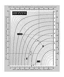
This diagram could be used also for star identification.[6]
An ambiguity in the value of azimuth may arise since in the diagram 0 ≤ Z ≤ 90°. Z is E/W as the name of the meridian angle, but the N/S name is not determined. In most situations azimuth ambiguities are resolved simply by observation.
When there are reasons for doubt or for the purpose of checking the following formula[7] should be used.
hav(Z) = [hav(90° - Dec) - hav(B - Hc)] / (1 - hav(B - Hc) - hav(B + Hc))
The algorithm if absolute values are used is:
if same name
 a = hav(90° - |Dec|)
if contrary name
 a = hav(90° + |Dec|)
m = hav(B + Hc)
n = hav(B - Hc)
q = n + m
hav(Z) = (a - n) / (1 - q)
Z = invhav -> look at the haversine tables
if Latitude N:
 if LHA > 180°, Zn = Z
 if LHA < 180°, Zn = 360° − Z
if Latitude S:
 if LHA > 180°, Zn = 180° − Z
 if LHA < 180°, Zn = 180° + Z
This computation of the altitude and the azimuth needs a haversine table. For a precision of 1 minute of arc, a four figure table is enough.[8]
An example
Data:
 B = 34° 10.0′ N (+)
 Dec = 21° 11.0′ S (-)
 LHA = 302° 43.0′
Altitude Hc:
 a = 0.2298
 m = 0.0128
 n = 0.2157
 hav(ZD) = 0.3930 -> table ->
 ZD = 77° 39′
 Hc  = 12° 21′
Azimuth Zn:
 a = 0.6807
 m = 0.1560
 n = 0.0358
 hav(Z) = 0.7979
 Zn  = 126.6°
See also
References
- ↑ The American Practical Navigator (2002)
- ↑ . Table de point miniature (Hauteur et azimut), by R. Doniol, Navigation IFN Vol. III Nº 10, Avril 1955 Paper
- ↑ Rudzinski, Greg (July 2015). Ix, Hanno. "Ultra compact sight reduction". Ocean Navigator. Portland, ME, USA: Navigator Publishing LLC (227): 42–43. ISSN 0886-0149. Retrieved 2015-11-07.
- ↑ Altitude haversine formula by Hanno Ix http://fer3.com/arc/m2.aspx/Longhand-Sight-Reduction-HannoIx-nov-2014-g29121
- ↑ Azimuth diagram by Hanno Ix. http://fer3.com/arc/m2.aspx/Gregs-article-havDoniol-Ocean-Navigator-HannoIx-jun-2015-g31689
- ↑ Hc by Azimuth Diagram http://fer3.com/arc/m2.aspx/Hc-Azimuth-Diagram-finally-HannoIx-aug-2013-g24772
- ↑ Azimuth haversine formula by Lars Bergman http://fer3.com/arc/m2.aspx/Longhand-Sight-Reduction-Bergman-nov-2014-g29441
- ↑ http://fer3.com/arc/m2.aspx/Longhand-Sight-Reduction-HannoIx-nov-2014-g29172
External links
- Navigational Algorithms: resources for Longhand Haversine Sight Reduction
- NavList A Community Devoted to the Preservation and Practice of Celestial Navigation and Other Methods of Traditional Position-Finding
- Celestial Tools for the USPS/CPS JN/N Student
- Graphical all-haversine Hc reduction