Simetsberg (Ester Mountains)
| Simetsberg | |
|---|---|
|
Simetsberg from the north | |
| Highest point | |
| Elevation | 1,840 m (6,040 ft) |
| Coordinates | 47°34′03″N 11°15′18″E / 47.56750°N 11.25500°ECoordinates: 47°34′03″N 11°15′18″E / 47.56750°N 11.25500°E |
| Geography | |
 Simetsberg Location in Germany | |
| Location | Bavaria, Germany |
| Parent range | Ester Mountains |
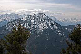
Simetsberg (elevation 1,840 metres/6,040 ft) is a mountain in the Bavarian Prealps of southern Germany. An isolated peak, it forms the eastern end of the Ester Mountains.[1]
References
- ↑ BY 9: Estergebirge, Herzogstand, Wank (Map). 1:25000. Alpenvereinskarte Bayerische Alpen (in German). Deutscher Alpenverein. 2009.
This article is issued from Wikipedia - version of the 11/16/2015. The text is available under the Creative Commons Attribution/Share Alike but additional terms may apply for the media files.