Sinclair Pass
| Sinclair Pass | |
|---|---|
| Elevation | 4,876 ft (1,486 m) |
| Traversed by | Highway 93 |
| Location | British Columbia, Canada |
| Range | Kootenay Ranges, Canadian Rockies |
| Coordinates | 50°40′24″N 115°56′8″W / 50.67333°N 115.93556°WCoordinates: 50°40′24″N 115°56′8″W / 50.67333°N 115.93556°W |
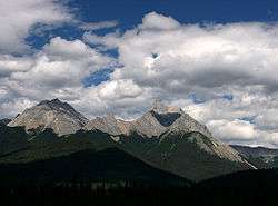
View to the south-east from the viewpoint near Sinclair Pass
Sinclair Pass (el. 1,486 m or 4,875 ft) is a high mountain pass in Kootenay National Park between the Columbia and Kootenay Rivers to the northeast of present-day Radium Hot Springs[1] in the province of British Columbia, Canada. It was named after James Sinclair. He discovered and used the pass in 1841, while leading an expedition consisting of 23 families, totaling 121 mostly metis settlers from the Red River Colony, across Rupert's Land to Fort Vancouver on the north bank of the Columbia River (across from present-day Portland, Oregon), in an attempt to hold the Columbia District for Britain.
See also
References
This article is issued from Wikipedia - version of the 3/2/2016. The text is available under the Creative Commons Attribution/Share Alike but additional terms may apply for the media files.