Sinnington
| Sinnington | |
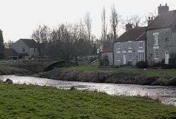 The bridge across the River Seven at Sinnington |
|
 Sinnington |
|
| Population | 287 (2011 census) |
|---|---|
| OS grid reference | SE744857 |
| Civil parish | Sinnington |
| District | Ryedale |
| Shire county | North Yorkshire |
| Region | Yorkshire and the Humber |
| Country | England |
| Sovereign state | United Kingdom |
| Post town | YORK |
| Postcode district | YO62 |
| Police | North Yorkshire |
| Fire | North Yorkshire |
| Ambulance | Yorkshire |
| EU Parliament | Yorkshire and the Humber |
| UK Parliament | Thirsk and Malton (formerly Ryedale) |
Coordinates: 54°15′43″N 0°51′32″W / 54.261900°N 0.858900°W
.jpg)
Sinnington is a village and civil parish in the Ryedale district of the county of North Yorkshire, England.[1] It is located on the southern boundary of the North York Moors National Park.
According to the 2001 UK census, the parish has a total population of 318 people living in 148 households,[2] reducing to 287 population at the 2011 Census.[3]
The nineteenth century agricultural writer, William Marshall, was born here in 1745.[4] The village was formerly served by a railway station on the Gilling and Pickering (G&P) railway line which opened in 1875 and closed on 31 January 1953[5] for both passengers and freight.
Typical of the area are the medieval cruck-built longhouses of Sinnington. These were constructed as single storey combined dwelling and beast houses and made of the local Jurassic limestone. Originally they had ling thatched roofs, but they were mostly re-roofed in the 19th century with grey slate or red pantiles.[6] All Saints' Church has in its fabric an assemblage of dozens of fragments of pre-Norman crosses and hogback fragments scattered all over the building, inside and out. It appears that several - perhaps the numbers even reach double figures - significant crosses were broken up in order to provide building stone for the twelfth-century workers who built the church.[7]
Governance
An electoral ward in the same name exists. This ward stretches south to Brawby with a total population taken at the 2011 census of 1,685.[8]
References
- ↑ "Sinnington Ward Profile" (PDF). Ryedale District Council. Retrieved 29 May 2009.
- ↑ "2001 Census: Key Statistics: Parish Headcounts: Area: Sinnington CP (Parish)". Neighbourhood Statistics. Office for National Statistics. Retrieved 29 May 2009.
- ↑ "Parish population 2011". Retrieved 13 August 2015.
- ↑ "EH.Net Encyclopedia: William Marshall". eh.net. Retrieved 26 May 2009.
- ↑ The Railways of Ryedale, Patrick Howat, 2004, p. 112
- ↑ Hartley, Marie; Ingilby, Joan (1972). Life in the Moorlands of North East Yorkshire. London: J M Dent and Sons Ltd. ISBN 0-460-03961-X.
- ↑ Tolley, Chris (February 2003). "Pre-Norman Stone Crosses in the British Isles - Sinnington". Crossing the Millennia. Archived from the original on 6 July 2008. Retrieved 23 February 2015.
- ↑ "Key Figures for 2011 Census: Key Statistics – Area: Sinnington (Ward)". Neighbourhood Statistics. Office for National Statistics. Retrieved 23 July 2016.
External links
![]() Media related to Sinnington at Wikimedia Commons
Media related to Sinnington at Wikimedia Commons