Sioma
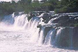
Sioma is a town in Shangombo District, Western Province, Zambia.[1][2] It is located near the Ngonye Falls, some of the most notable on the Zambezi and are viewable from canoe or the road.[3][4][5][6] Sioma is adjacent to Sioma Ngwezi National Park.[7]
History
There was an Iron Age settlement at the location of the current village.[8][9]
Some of the pottery in the village resembles that which is found in Nqoma, Angola.[10]
In 1881, the village was described by Alexandre Alberto da Rocha de Serpa Pinto as a hamlet. At the time, the Lui government forced local residents to act as porters for canoes attempting to get around the falls.[11] Two years later, James Dabney McCabe described the village the same way, as a hamlet.[12]
Location
It is located at 6.75 S–23.61 E.[13][14][15] It is located 60 kilometres (37 mi) southeast of Kalongola.[4] Another village close by is Siluanna.[16] Samabi is located 4 miles (6.4 km) away and Chanyati is located 5.8 miles (9.3 km) away.[17]
Vegetation
Vegetation in the area is Dry Kalahari woodland.[13]
Weather
Annually, the town gets an average of 737 millimetres (29.0 in) of rain.[13]
| Climate data for Sioma, Zambia | |||||||||||||
|---|---|---|---|---|---|---|---|---|---|---|---|---|---|
| Month | Jan | Feb | Mar | Apr | May | Jun | Jul | Aug | Sep | Oct | Nov | Dec | Year |
| Average high °C | 22 | 20 | 23 | 25 | 23 | 22 | 21 | 25 | 27 | 28 | 27 | 24 | 23.9 |
| Average low °C | 15 | 16 | 15 | 13 | 11 | 9 | 7 | 10 | 13 | 15 | 15 | 14 | 12.8 |
| Average precipitation mm | 165 | 147 | 90 | 21 | 0 | 0 | 0 | 0 | 0 | 15 | 30 | 162 | 630 |
| Average high °F | 72 | 68 | 73 | 77 | 73 | 72 | 70 | 77 | 81 | 82 | 81 | 75 | 75.1 |
| Average low °F | 59 | 61 | 59 | 55 | 52 | 48 | 45 | 50 | 55 | 59 | 59 | 57 | 54.9 |
| Average precipitation inches | 6.5 | 5.79 | 3.54 | 0.83 | 0 | 0 | 0 | 0 | 0 | 0.59 | 1.18 | 6.38 | 24.81 |
| Average precipitation days | 19 | 16 | 16 | 7 | 1 | 0 | 0 | 1 | 1 | 6 | 9 | 18 | 94 |
| Source #1: [17] | |||||||||||||
| Source #2: [18] | |||||||||||||
Buildings and industry
The Roman Catholic Church, St. Anthony, was founded in Sioma in 1953. The church was seen to by the Franciscan Missionary Srs for Africa.[19] The village has a hospital.[19] A safari company based in the town is Maziba Bay River Safaris.[20] There are elephants routes located near the town.[21]
The nearest airport is founded in Senanga, 42.9 miles (69.0 km) away.[17] The lack of an airport made it difficult to establish a refugee camp near the village.[22]
Industries in the village have included "ivory trade, river transport and porterage".[23] There have been efforts been made to develop tourism around the Sioma.[24]
See also
References
- ↑ Willie Olivier, Sandra Olivier. Overland Through Southern Africa. Struik, 1998. ISBN 1868721051.
- ↑ Godfrey Mwakikagile (30 April 2010). Zambia: Life in an African Country. Godfrey Mwakikagile. pp. 36–. ISBN 978-9987-16-011-2. Retrieved 18 June 2012.
- ↑ Godfrey Mwakikagile (May 2010). Zambia: The Land and Its People. Godfrey Mwakikagile. pp. 35–. ISBN 978-9987-9322-5-2. Retrieved 18 June 2012.
- 1 2 Alan Murphy; Kate Armstrong; James Bainbridge; Matthew D. Firestone (11 March 2010). Southern Africa. Lonely Planet. pp. 668–. ISBN 978-1-74059-545-2. Retrieved 18 June 2012.
- ↑ Willie Olivier; Sandra Olivier (1998). Overland Through Southern Africa. Struik. p. 112. ISBN 978-1-86872-105-4. Retrieved 18 June 2012.
- ↑ Julian Wicksteed (13 November 2008). A Catch on Africa - An Angler's Walkabout Adventure. Lulu.com. pp. 94–. ISBN 978-1-4092-0527-2. Retrieved 18 June 2012.
- ↑ "Sioma village". African Safari Travel. Retrieved June 18, 2012.
- ↑ National Museums of Zambia; Livingstone Museum (1973). Zambia museums journal. National Museums of Zambia. Retrieved 18 June 2012.
- ↑ The South African archaeological bulletin. South African Archaeological Society. 1978. Retrieved 18 June 2012.
- ↑ Jan Vansina (2004). How Societies Are Born: Governance in West Central Africa Before 1600. How Societies Are Born: Governance in West Central Africa before 1600. pp. 109–. ISBN 978-0-8139-2279-9. Retrieved 18 June 2012.
- ↑ Alexandre Alberto da Rocha de Serpa Pinto (1881). How I crossed Africa: from the Atlantic to the Indian Ocean, through unknown countries; discovery of the great Zambesi affluents, &c. J. B. Lippincott & co. Retrieved 18 June 2012.
- ↑ James Dabney McCabe (1883). Our young folks in Africa: the adventures of a party of young Americans in Algeria and in South Central Africa. J.B. Lippincott & Co. Retrieved 18 June 2012.
- 1 2 3 Ignacio Rodríguez-Iturbe; Amilcare Porporato (2004). Ecohydrology Of Water-Controlled Ecosystems: Soil Moisture And Plant Dynamics. Cambridge University Press. pp. 167–. ISBN 978-0-521-81943-5. Retrieved 18 June 2012.
- ↑ George Philip; George Philip & Son (1 November 1987). Great International Atlas. Portland House. ISBN 978-0-517-63579-7. Retrieved 18 June 2012.
- ↑ George Philip & Son; Oxford University Press (1998). Oxford essential world atlas. Published in North America by Oxford University Press. ISBN 978-0-19-521466-6. Retrieved 18 June 2012.
- ↑ Colin Graham Trapnell; Royal Botanic Gardens, Kew (2001). Ecological survey of Zambia: the traverse records of C.G. Trapnell, 1932-43. Royal Botanic Gardens Kew. ISBN 978-1-84246-002-3. Retrieved 18 June 2012.
- 1 2 3 "Sioma, Zambia Weather Averages | Monthly Average High and Low Temperature | Average Precipitation and Rainfall days". World Weather Online. Retrieved 2012-06-18.
- ↑ "Sioma June Weather 2012 - AccuWeather Forecast for Western Zambia". Accuweather.com. 2012-01-06. Retrieved 2012-06-18.
- 1 2 Church of the Province of South Africa. Diocese of Pretoria; Catholic Church. Southern African Catholic Bishops' Conference (1 January 1988). The Catholic directory of Southern Africa. Southern African Catholic Bishops' Conference. ISBN 978-0-620-10992-5. Retrieved 18 June 2012.
- ↑ Ibp Usa; USA (COR) International Business Publications (7 February 2007). Zambia Country Study Guide. Int'l Business Publications. pp. 186–. ISBN 978-1-4330-6001-4. Retrieved 18 June 2012.
- ↑ Sam Cushman; Falk Huettmann (1 February 2010). Spatial Complexity, Informatics, and Wildlife Conservation. Springer. pp. 363–. ISBN 978-4-431-87770-7. Retrieved 18 June 2012.
- ↑ "IRIN Africa | ANGOLA-ZAMBIA: Stranded refugees rescued | Angola | Zambia | Refugees/IDPs". Irinnews.org. Retrieved 2012-06-30.
- ↑ Hugh MacMillan; Hugh MacMillan (Ph. D.) (22 July 2005). An African Trading Empire: The Story of Susman Brothers & Wulfsohn, 1901-2005. I.B.Tauris. pp. 7–. ISBN 978-1-85043-853-3. Retrieved 18 June 2012.
- ↑ 5 July 2010 (2010-07-05). "Zambia: State Offers Investors Tourism Goldmine Along the Zambezi". allAfrica.com. Retrieved 2012-06-30.
Coordinates: 16°40′S 23°32′E / 16.667°S 23.533°E