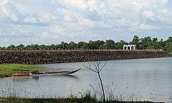
Sirindhorn Dam Reservoir
| Sirindhorn Dam Reservoir | |
|---|---|
 | |
| Location | Sirindhorn District, Ubon Ratchathani Province, Thailand |
| Coordinates | 15°5′0″N 105°22′46″E / 15.08333°N 105.37944°ECoordinates: 15°5′0″N 105°22′46″E / 15.08333°N 105.37944°E |
| Type | Reservoir |
| Primary inflows | Dom Noi River |
| Primary outflows | Dom Noi River |
| Catchment area | 2,100 km2 (810 sq mi) |
| Basin countries | Thailand |
| Max. length | 43 km (27 mi) |
| Surface area | 292 km2 (113 sq mi) |
| Average depth | 5.1 m (17 ft)[1] |
| Water volume | 1,966,500,000 m3 (6.945×10¹⁰ cu ft) |
| Settlements | Chong Mek, Sirindhorn, Kham Khuean Kaeo, Buntharik |
The Sirindhorn Dam Reservoir is a reservoir in the Sirindhorn District of Ubon Ratchathani Province, Thailand. The reservoir is formed by the damming of the Dom Noi River at the Sirindhorn Dam.
The reservoir and dam power the Sirindhorn Hydropower Plant, which has an installed capacity of 3 units of 12,000 kilowatts each and annual energy production of 90 GWh.[2]
History
The reservoir was created in 1968 with the construction of the Sirindhorn Dam. The dam's electricity production started in 1971.[2]
Recreation
There is a park near the dam headquarters and a restaurant and bungalows for visitors.[3] There is a golf course in this area also, at the north end of the lake.[4]
References
- ↑ "Variations and patterns of fish yields in large reservoirs in Thailand" (PDF). National Institute for Environmental Studies (Japan). 17 January 2011. Retrieved 12 March 2013.
- 1 2 "Renovation of Small Hydropower Plants". Electricity Generating Authority of Thailand. Archived from the original on 10 July 2011. Retrieved 12 March 2013.
- ↑ Thailand (Eyewitness Travel Guides) (1st American ed.). DK Publishing, Inc. 1997. p. 289. ISBN 0-7894-1949-1.
- ↑ Sirindhorn Reservoir (Map). Google Maps. Retrieved 12 March 2013.
This article is issued from Wikipedia - version of the 11/10/2016. The text is available under the Creative Commons Attribution/Share Alike but additional terms may apply for the media files.