Skytrail
| Skytrail | |
|---|---|
 | |
| Coordinates | 51°29′24.53″N 107°4′20.83″W / 51.4901472°N 107.0724528°WCoordinates: 51°29′24.53″N 107°4′20.83″W / 51.4901472°N 107.0724528°W |
| Carries |
Pedestrian (current) Railway (former) |
| Crosses | South Saskatchewan River |
| Locale | Outlook, Saskatchewan, Canada |
| Characteristics | |
| Design | Truss bridge |
| Material | Steel |
| Total length | 3,000 feet (910 m) |
| Height | 150 feet (46 m) |
| History | |
| Designer | J.D. McArthur and Company |
| Construction begin | January 24, 1910 |
| Construction end | October 23, 1912 |
| Opened | October 23, 1912 |
| Closed | March 16th, 1987 (railway) |
The Skytrail Bridge spans the South Saskatchewan River in Outlook, Saskatchewan, Canada. It was originally built by the Canadian Pacific Railway over the full width of the river's flood channel and has eight spans.[1] It served as a railway bridge from October 23, 1912, until March 16, 1987. In 2003 it was converted to a pedestrian bridge and is now the longest pedestrian bridge in Canada.[2] The bridge is part of the Trans-Canada Trail.
 A panorama view of the Skytrail
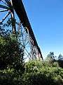 View from below the bridge
See also
References
- ↑ Smith, C.D. (1984). "Scour control at Outlook Bridge-A case study". Can. J. Civ. Eng. NRC Research Press. 11 (4): 709–716. doi:10.1139/l84-091. Retrieved 16 March 2014.
- ↑ SkyTrail - Canada's Longest Pedestrian Bridge
External links
This article is issued from Wikipedia - version of the 9/26/2015. The text is available under the Creative Commons Attribution/Share Alike but additional terms may apply for the media files.