Slapton, Devon
Coordinates: 50°18′N 3°39′W / 50.300°N 3.650°W

Slapton is a village and civil parish in the South Hams district of Devon, England. It is located near the A379 road between Kingsbridge and Dartmouth, and lies within the South Devon Area of Outstanding Natural Beauty (AONB). In 1901 the population of the civil parish was 527,[1] decreasing to 473 in 2001,[2] and decreasing further to 434 at the 2011 census.[3] The parish is surrounded clockwise from the north by the parishes of Blackawton, Strete, Stokenham and East Allington.[4]
History
Slapton was recorded in the Domesday Book as Sladone.[5] The Collegiate Chantry of St Mary was founded in 1372 or 1373 by Sir Guy de Brian.[6] The Tower Inn and West tower remain and the tower has been designated by English Heritage as a grade I listed building.[7] The Church of St James dates from the late 13th or early 14th century, and is also grade I listed.[8]
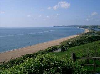
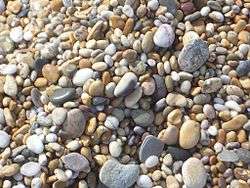
The nearby beach which is technically a coastal bar (see below), known as Slapton Sands, was in 1944 part of the site of the ill-fated Exercise Tiger. A Sherman tank that was sunk in this action has been recovered and now stands on the road behind the beach at nearby Torcross. Part of Exercise Fabius took place a week after Exercise Tiger on Slapton Sands. The beach itself is not sand, but consists of small smooth pebbles ranging in size from ¼ inch to several inches..
Geography and environmental importance
Behind Slapton Sands is Slapton Ley, a nature reserve and good example of serial or ecological succession — the process whereby open water becomes reed bed and eventually, as silt and leaf litter builds up, woodland. The beach itself is a good example of a bar: the material that makes up the beach was pushed up by the rising sea levels during the Flandrian transgression after the last glacial period (from 10,000 to 5,000 years ago). A similar process formed Chesil Beach. Beaches formed like this are reworked by coastal processes now but are not supplied by enough material to recreate them, should material be removed. This had terrible consequences nearby at Hallsands where most of the beach was removed as building material for Devonport dockyards, leaving the village exposed to storms. It was struck by a storm in 1917 and most of the village was washed away although no villagers were killed.[9]
Further north, the beach is known as Strete Sands and at the northernmost end is Pilchard Cove. The southern end of the beach is known as Torcross Sands. A length of beach about 800 metres (870 yd) south of Pilchard Cove is regularly used by naturists.[10][lower-alpha 1]
Gallery
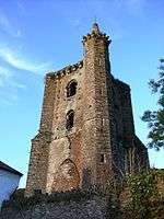 Tower of the Collegiate Chantry of St Mary
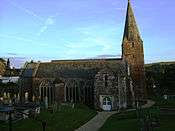 Church of St James
 Monument on Slapton Sands
See also
Notes and references
- ↑ Location of Slapton nudist beach 50°18′08″N 3°37′59″W / 50.302110°N 3.632976°W
- ↑ Harris, Helen (2004). A Handbook of Devon Parishes. Tiverton: Halsgrove. p. 163. ISBN 1-84114-314-6.
- ↑ "Slapton Parish Headcounts 2001". neighbourhood.statistics.gov.uk. 1 January 2007. Retrieved 2016-07-15.
- ↑ "Parish population 2011.Retrieved 6 April 2015".
- ↑ "Map of Devon Parishes" (PDF). Devon County Council. Retrieved 27 July 2015.
- ↑ "Slapton, Devon Folio: 102r Great Domesday Book Domesday". The National Archives. 1086. Retrieved 2016-07-15.
- ↑ "Tower Inn". Tower Inn. Archived from the original on 2007-06-29. Retrieved 2007-08-10.
- ↑ "Tower of Collegiate Chantry of St Mary". Images of England. Retrieved 2007-08-10.
- ↑ "Church of St James". Images of England. Retrieved 2007-08-10.
- ↑ "Hallsands". South Devon AONB. Retrieved 18 August 2015.
- ↑ "Devon, Cornwall and Somerset's coastline lost millions of tonnes of sand after winter storms". Western Morning News. 22 September 2014. Retrieved 2016-07-15.
External links
| Wikimedia Commons has media related to Slapton, Devon. |