Slatina Peak

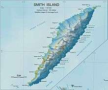
Slatina Peak (Bulgarian: връх Слатина, ‘Vrah Slatina’ \'vr&h 'sla-ti-na\) is a peak rising to 1750 m in Imeon Range on Smith Island, South Shetland Islands. Situated 2 km northeast of Antim Peak, to which it is linked by Varshets Saddle, 4.09 km east by south of Villagra Point, and 1.9 km south of Drinov Peak. Overlooking the upper part of Chuprene Glacier to the northwest, and Krivodol Glacier to the southwest and south. Bulgarian early mapping in 2009. Named after the Bulgarian settlements of Slatina in Montana, Lovech, Plovdiv, Silistra and Sofia regions (the last one now part of the city of Sofia).
Coordinates: 62°58′08″S 62°29′30″W / 62.96889°S 62.49167°W
Map
- L.L. Ivanov. Antarctica: Livingston Island and Greenwich, Robert, Snow and Smith Islands. Scale 1:120000 topographic map. Troyan: Manfred Wörner Foundation, 2009. ISBN 978-954-92032-6-4
References
This article includes information from the Antarctic Place-names Commission of Bulgaria which is used with permission.