Slave Craton
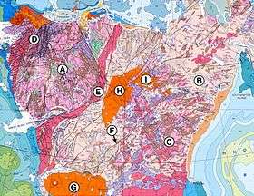

The Slave Craton is an Archaean craton in the north-western Canadian Shield, in Northwest Territories and Nunavut. The Slave Craton includes the 4.03 Ga-old Acasta Gneiss which is one of the oldest dated rocks on Earth.[1][2] Covering about 300,000 km2 (120,000 sq mi), it is a relatively small but well-exposed craton dominated by about 2.73-2.63 Ga (billion years-old) greenstones and turbidite sequences and ca. 2.72-2.58 Ga plutonic rock, with large parts of the craton underlain by older gneiss and granitoid units.[3] The Slave Craton is one of the blocks that compose the Precambrian core of North America, also known as the palaeocontinent Laurentia.[4]
The exposed portion of the craton, called the Slave Province, comprises 172,500 km2 (66,600 sq mi) and has an elliptical shape that stretches 680 km (420 mi) NNE from Gros Cap on the Great Slave Lake to Cape Barrow on the Coronation Gulf and 460 km (290 mi) EW along latitude 64°N.[4] It covers about 700 km × 500 km (430 mi × 310 mi) and is bounded by Palaeoproterozoic belts to the south, east, and west, while younger rocks cover it to the north.[5]
The Slave Craton is divided into a west-central basement complex, the Central Slave Basement Complex, and an eastern province, named the Hackett River Terrane or the Eastern Slave Province. These two domains are separated by a 2.7 Ga-old suture defined by two isotopic boundaries running north to south over the craton.[6]
Central Slave Basement Complex

The Central Slave Basement Complex (CSBC) is the basement under the central and western part of the craton. Along the Acasta River the CSBC includes the Acasta Gneisses with a protolith age of about 4.03 Ga, the oldest dated rock unit on Earth. These gneisses are polymetamorphic and have a tonalitic and gabbroic composition. The rest of the CSBC is younger with a central core younger than 3.5 Ga and the remaining craton has detrial and protolith ages ranging from 3.4 to 2.8 Ga.[2] The basement complex is overlain by Neoarchaean supracrustal sequences and intruded by plutonic suites.[7] The Acasta gneisses are geochemically similar to other Archaean complexes but, four billion years old, they contain even older zircon cores. These cores indicate that the parental magmas of such complexes formed by interaction between the zircon-bearing crust and mantle-derived melts. No such older Acasta gneisses have been discovered yet, but the zircon cores indicate they exist.[8]
The CSBC's eastern extent is unknown but the complex dips to the east and underlies the central part of the craton. Attempts to reconstruct the craton's tectonic history have focused extensively on this east-west asymmetry. The presence of a collisional suture suggests the CSBC collided with an island arc terrane along a North-South-directed before 2.69 Ga. Alternatively, the Eastern Slave can be an attenuated and modified Mesoarchaean lithosphere which developed during rifting at 2.85–2.70 Ga. The mantle lithosphere under the western Slave can be 400 Ma older than that underlying the eastern Slave.[5][9]
Back River Volcanic Complex
The Back River volcanic complex is an Arachaean stratovolcano preserved in an upright position surrounded by four sedimentary sequences reflecting the volcano's magmatic history. An exposed dome in the southern half of the complex is the eroded portion of the volcano. In contrast to the remaining craton, the complex has only undergone a low degree of deformation.[10]
See also
References
Notes
- ↑ Stern & Bleeker 1998, Summary
- 1 2 Bleeker et al. 2004, Basement complex, p. 1
- ↑ Bleeker, Stern & Sircombe 2000, Slave Craton and previous investigations, pp. 2–3
- 1 2 Helmstaedt 2009, Geological setting, pp. 1056–1057
- 1 2 Davis et al. 2003, Geological background
- ↑ Jones & Garcia 2006, Geological setting, pp. 126–127
- ↑ Bleeker 2011
- ↑ Bowring & Williams 1999, Implications of zircon data, pp. 14–15
- ↑ Davis et al. 2003, Fig. 1, p. 576
- ↑ Villeneuve et al. 2001, Introduction, p. 2
Sources
- Bleeker, W. (2011). The Slave Craton of North America: an Overview. GSA Annual Meeting & Exposition. Minneapolis. Retrieved May 2016. Check date values in:
|access-date=(help) - Bleeker, W.; Davis, B.; Ketchum, J.; Stern, R.; Sircombe, K.; Waldron, J. (2004). "The Slave Craton From On Top: The Crustal View" (PDF). Geological Survey of Canada. Retrieved May 2016. Check date values in:
|access-date=(help) - Bleeker, W.; Stern, R.; Sircombe, K. (2000). "Why the Slave Province, Northwest Territories, got a little bigger" (PDF). Geological Survey of Canada, Current Research. Retrieved May 2016. Check date values in:
|access-date=(help) - Bowring, S. A.; Williams, I. S. (1999). "Priscoan (4.00–4.03 Ga) orthogneisses from northwestern Canada" (PDF). Contributions to Mineralogy and Petrology. 134 (1): 3–16. doi:10.1007/s004100050465. Retrieved May 2016. Check date values in:
|access-date=(help) - Davis, W. J.; Jones, A. G.; Bleeker, W.; Grütter, H. (2003). "Lithosphere development in the Slave craton: a linked crustal and mantle perspective" (PDF). Lithos. 71 (2): 575–589. Bibcode:2003Litho..71..575D. doi:10.1016/S0024-4937(03)00131-2. Retrieved May 2016. Check date values in:
|access-date=(help) - Helmstaedt, H. (2009). "Crust–mantle coupling revisited: the Archean Slave craton, NWT, Canada" (PDF). Lithos. 112: 1055–1068. doi:10.1016/j.lithos.2009.04.046. Retrieved May 2016. Check date values in:
|access-date=(help) - Jones, A. G.; Garcia, X. (2006). "Electrical resistivity structure of the Yellowknife River Fault Zone and surrounding region" (PDF). In Anglin, C. D.; Falck, H.; Wright, D. F.; Ambrose, E. J. Gold in the Yellowknife Greenstone Belt, Northwest Territories: Results of the EXTECH III. Geological Association of Canada, Special Publication no. 3. pp. 126–141. doi:10.1139/e05-080. Retrieved May 2016. Check date values in:
|access-date=(help) - Stern, R. A.; Bleeker, W. (1998). "Age of the world's oldest rocks refined using Canada's SHRIMP: The Acasta Gneiss Complex, Northwest Territories, Canada" (PDF). Geoscience Canada. 25 (1): 27–31. Retrieved May 2016. Check date values in:
|access-date=(help) - Villeneuve, M.; Lambert, M.; van Breemen, O.; Mortensen, J. (2001). "Geochronology of the Back River volcanic complex, Nunavut-Northwest Territories" (PDF). Geological Survey of Canada, Current Research. Retrieved May 2016. Check date values in:
|access-date=(help)