Municipal Borough of Slough
Coordinates: 51°30′36″N 0°35′35″W / 51.51°N 0.593056°W
| Slough | |
|---|---|
 Slough within Buckinghamshire in 1971 | |
| Area | |
| • 1911 | 1,684 acres (6.81 km2) |
| • 1931 | 6,145 acres (24.87 km2) |
| • 1961 | 6,202 acres (25.10 km2) |
| Population | |
| • 1911 | 14,982 |
| • 1931 | 33,530 |
| • 1961 | 80,781 |
| Density | |
| • 1911 | 8.9/acre |
| • 1931 | 5.5/acre |
| • 1961 | 13.0/acre |
| History | |
| • Created | 1863 |
| • Abolished | 1974 |
| • Succeeded by | Slough |
| Status |
Local government district (1863–1894) Urban district (1894–1938) Municipal borough (1938–1974) |
| • Motto | FIDUCIA ET VI (By confidence and strength) |
 Coat of arms | |
Slough was, from 1863 to 1974, a local government district in southern Buckinghamshire, England.[1] It became an urban district in 1894 and was incorporated as a municipal borough in 1938. It was abolished in 1974 and now forms part of the borough of Slough in Berkshire.
Formation
The Local Government Act 1858 was adopted in 1863 for town of Slough, that was partly in the parishes of Upton cum Chalvey and Stoke Poges, creating a local government district governed by Slough Local Board of Health.
Following the Local Government Act 1894, its area was reconstituted as an urban district consisting of the civil parishes of Slough and Stoke-in-Slough. The local authority became Slough Urban District Council. Slough absorbed Stoke-in-Slough in 1896.[1] The remaining portions of Upton cum Chalvey and Stoke Poges became part of Eton Rural District.
Boundary changes
The district was subject to a number of boundary changes, which incorporated territory from Eton Rural District.
In 1900 the urban district gained part of Langley Marish and more of the Upton cum Chalvey civil parishes.
In 1930, as part of a county review order, it gained 4,461 acres (18.05 km2) of Burnham, Dorney, Farnham Royal, Horton, Langley Marish and Stoke Poges.
In 1931, as part of another county review order, it gained 57 acres (0.23 km2) of Farnham Royal and Stoke Poges.
Incorporation

In 1938, under the provisions of the Municipal Corporations Act 1882, the urban district was incorporated by royal charter as a municipal borough and the local authority became Slough Borough Council.
Coat of arms
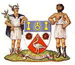
A coat of arms and motto were granted on 3 September 1938. The coat of arms depicts a swan, the county emblem of Buckinghamshire and brick-axes, indicating local brick-making. The sign for Uranus is taken from the arms of the Herschel family, referring to the discovery of the planet by astronomer William Herschel. The supporters are symbols of trade and industry. The motto Fiducia et vi means 'By confidence and strength'.[2]
Politics
Eton Union Board of Guardians
The parish of Upton-cum-Chalvey was, for poor law purposes, included in the Eton Poor Law Union and represented on its Board of Guardians from 1835. This was the first partially elected local government body including a portion of the area which now forms the modern Borough. The whole parish (which included roughly the modern wards of Central, Chalvey and Upton) elected one Guardian, later rising to two (until 1874) and three thereafter.
Some other parishes, now wholly or partially in the present Borough, were also part of the Eton Union. Langley Marish, to the east of Upton-cum-Chalvey, elected two Guardians in 1835. Wexham to the north had one representative on the Board, as did Stoke Poges (to the north-west), Farnham Royal and Burnham (both to the west).
In 1894, with the establishment of civil parishes and Urban District Councils, Upton-cum-Chalvey was for civil purposes reduced to the part of the traditional parish not then included in Slough (approximately the modern Chalvey ward). It continued to send two members to the Board of Guardians, who also served on the Eton Rural District Council (the part of Eton Union not included in an Urban District Council), until the area was incorporated in Slough Urban District in 1900.
The Slough Urban District area elected two members of the Board of Guardians from 1894 until 1901, when the expanded Urban District returned four Guardians. In 1907 Slough was given six seats on the Board. This representation continued until 1930, when the poor law Unions and Boards of Guardians were abolished and their functions transferred to County Councils.
Buckinghamshire County Council
When elected County Councils were introduced in 1889 Slough returned one County Councillor. In 1904 the enlarged Slough was split into three single-member County Electoral Divisions.
Following the expansion of Slough in 1930–1931 (incorporating approximately the modern Baylis & Stoke ward to the north and the modern Farnham, Haymill, Cippenham Green and Cippenham Meadows wards to the west) the Urban District (from 1938 the Municipal Borough) of Slough continued to be represented in the County Council until the reorganisation of local government led to the abolition of the first Buckinghamshire County Council in 1974.
Buckinghamshire County Electoral Divisions in Slough 1889–1974
- 1889–1904 1
- 1904–1931 3
- 1931–1934 4
- 1934–1952 6
- 1952–1974 9
Slough and Upton-cum-Chalvey civil parishes
In 1894 the Slough urban sanitary district became a distinct civil parish, as did the rest of Upton-cum-Chalvey. The civil parish of Slough was the same year converted to Slough Urban District.
Upton-cum-Chalvey civil parish elected an eleven-member Parish Council, which administered the area until the merger with Slough in 1900. The western part of the Langley Marish area (the whole of which is now approximately the three wards of Foxborough, Kedermister and Langley St Mary's) was also incorporated in the expanded Urban District. The rest of Langley was not added to Slough until the 1930–31 boundary changes.
| Party in control | Years | |
|---|---|---|
| Independent | 1863-1946 | |
| No overall control | 1946–1952 | |
| Labour | 1952–1955 | |
| No overall control | 1955–1956 | |
| Labour | 1956–1967 | |
| Conservative | 1967–1972 | |
| Labour | 1972–1974 | |
Abolition
The borough was abolished in 1974 and its former area was combined with part of Eton Rural District to form the borough of Slough in Berkshire.[1]
References
- 1 2 3 Youngs, Frederic (1979). Guide to the Local Administrative Units of England. I: Southern England. London: Royal Historical Society. ISBN 0-901050-67-9.
- ↑ "Buckinghamshire (obsolete)". Civic Heraldry of England and Wales.
- Local newspapers (1863-date) and Slough Borough Council documents at the Robert Taylor Library in Slough
External links
| Ancient boroughs | |
|---|---|
| Incorporated boroughs | |
| Urban districts | |
| Rural districts | |
| Civil parishes | |