Smyadovo Cove
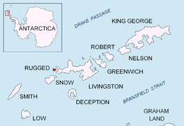

Smyadovo Cove (Bulgarian: залив Смядово, ‘Zaliv Smyadovo’ \'za-liv 'smya-do-vo\) is a 900 m wide cove indenting for 850 m the west coast of Rugged Island off the west coast of Byers Peninsula of Livingston Island in the South Shetland Islands, Antarctica. Entered north of Ugain Point and south of the southwest extremity of the small peninsula forming Cape Sheffield. Part of the cove's interior and entrance is occupied by Toledo Island and Prosechen Island.
The cove is named after the town of Smyadovo in northeastern Bulgaria.
Location
Smyadovo Cove is centred at 62°37′23.4″S 61°17′30″W / 62.623167°S 61.29167°WCoordinates: 62°37′23.4″S 61°17′30″W / 62.623167°S 61.29167°W. British mapping in 1968, Spanish in 1992 and Bulgarian in 2005 and 2009.
Map
- L.L. Ivanov. Antarctica: Livingston Island and Greenwich, Robert, Snow and Smith Islands. Scale 1:120000 topographic map. Troyan: Manfred Wörner Foundation, 2009. ISBN 978-954-92032-6-4
References
This article includes information from the Antarctic Place-names Commission of Bulgaria which is used with permission.