Soberanes Fire
| Soberanes Fire | |
|---|---|
|
| |
| Location | Soberanes Creek, Garrapata State Park, Monterey County, California |
| Coordinates | 36°27′36″N 121°53′58″W / 36.45994°N 121.89938°W |
| Statistics[1] | |
| Cost | $236 million (As of 5 October 2016) |
| Date(s) | July 22, 2016 – October 12, 2016 (82 days) |
| Burned area | 132,127 acres (53,470 ha) |
| Cause | Illegal campfire |
| Land use | Residential; open space |
| Buildings destroyed |
|
| Fatalities | 1 bulldozer operator |
| Perpetrator(s) | Unknown |
| Map | |
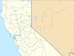
 Location in Northern California | |
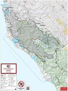
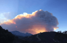
The Soberanes Fire was as of 2016 the most expensive wildfire in United States history.[2][3] It was the result of illegal campfire in Garrapata State Park and cost about $236 million to suppress. The fire burned 132,127 acres (53,470 ha) along the Big Sur coast in the Los Padres National Forest, Ventana Wilderness, and adjacent private and public land in Monterey County, California.[1][4][5] At the fire's peak, over 5000 personnel were assigned to the blaze. The Soberanes fire is the 18th of the top 20 largest California wildfires in terms of acres burned.[6]
Events


The fire was first reported by hikers at 8:48 a.m. on Friday 22 July 2016,[1] and was later determined to be the result of an illegal campfire.[7][8] By Saturday morning, the fire had grown to 2,000 acres (810 ha) and forced the evacuation of the community of Palo Colorado.[9]
By the morning of Sunday 24 July, the fire had grown to over 10,000 acres (4,000 ha), with 5% of the perimeter contained.[10] Officials said that Toro Park would be closed so that firefighters could use the area as a base camp. Evacuation warnings were also issued for all of Carmel Highlands.[10]
On Tuesday 26 July, acting California governor Tom Torlakson declared a state of emergency in Monterey County over the fire.[11][12]
By Saturday 30 July, the fire had spread to the Los Padres National Forest.[13]
By August 26, the fire had grown to over 90,000 acres (36,000 ha) and was 60% contained.[1] The majority of the fire by then was within the Los Padres National Forest, and unified command of the fire suppression work was transferred from the California Department of Forestry and Fire Protection to the United States Forest Service's Alaska Interagency Incident Management Team.[14][15]
By September 18, the fire had grown to 113,260 acres (45,830 ha). Containment was at 61%, and 1,921 firefighters were at work. Some evacuation orders have been lifted, and crews are working on burn out operation to establish a containment line on the northeast side of the fire, near Chews Ridge. Heavy smoke resulted from the burnouts.[1] As of 23 September 2016 the costs to fight the fire exceeded $200 million, the most expensive fire in United States history.[16]
On October 9, the fire had burned 132,127 acres (53,470 ha) and was 99% contained. Incident management personnel expected to attain full containment by October 15. Fire personnel had been reduced to 704 workers with many engaged in fire suppression repair efforts. On October 28, fire management personnel reported that the fire was 100% contained, and that remaining smouldering hotspots would be put out by rains expected shortly afterward. Restoration crews had completed suppression repair work on 374 miles (602 km) of fire line.[1]
Damages and deaths

On Tuesday 26 July, Robert Oliver Reagan, an on-call bulldozer operator, was killed when his bulldozer rolled over while cutting line on a steep slope in the Palo Colorado Canyon area.[17][18]
The fire destroyed 57 homes and 11 outbuildings in the Garrapata Canyon and Palo Colorado Canyon areas during the first three weeks.[1] Robert Baird, supervisor of the Los Padres National Forest, estimated that firefighters saved US$6.8 billion worth of real estate.[19]
The fire burned and possibly killed the largest Pacific madrone tree in the United States within the Joshua Creek Canyon Ecological Reserve. The tree was 125 feet (38 m) tall and more than 25 feet (7.6 m) in diameter. The madrone was listed on the American Forests National Big Tree list, a register of the biggest trees by species in the United States.[20]
The California Department Of Parks And Recreation announced on September 28, 2016 that Garrapata State Park east of Highway 1, where the fire started, would remain closed through the winter.[21]
Cause
On August 2, officials announced that their investigation found that the fire had been caused by an illegal campfire.[7] While no suspect was identified, Monterey County District Attorney Dean Flippo said that, if an arrest were made, the culprit could be charged with negligence and manslaughter.[7]
See also
References
- 1 2 3 4 5 6 7 "Soberanes Fire". InciWeb. Retrieved 15 September 2016.
- ↑ Geiling, Natasha (23 September 2016). "California fire becomes the most expensive in history". ThinkProgress. Retrieved 15 November 2016.
- ↑ Gilpin, Lyndsey (October 5, 2016). "The Most Expensive Wildfires in US History". High Country News.
- ↑ "Soberanes Fire map". InciWeb Incident Information System. National Wildfire Coordinating Group. Retrieved August 6, 2016.
- ↑ Wright, Tommy (September 1, 2016). "Soberanes Fire could be beneficial for condors". Monterey Herald. Retrieved 4 September 2016.
- ↑ "SOBERANES FIRE". Big Sur Fire Brigade. 12 October 2016. Retrieved 4 October 2016.
- 1 2 3 Larson, Amy (2 August 2016). "Soberanes Fire caused by illegal unattended campfire, Cal Fire says". Retrieved 2 August 2016.
- ↑ Precious time was lost between the time the hikers spotted the fire and were able to hike to a location where they could connect to a cell phone repeater to report it.
- ↑ Seaver, Lauren (23 July 2016). "2,000-acre Soberanes Fire in Garrapata State Park forces evacuations". KSBW. Retrieved 24 July 2016.
- 1 2 Seaver, Lauren. "Soberanes Fire grows to 10,262 acres; containment up to 5 percent". KSBW. Retrieved July 24, 2016.
- ↑ "Acting Governor Torlakson Declares State of Emergency in Los Angeles and Monterey Counties". Office of the Governor. July 26, 2016. Retrieved July 31, 2016.
- ↑ Myers, John (July 25, 2016). "Who's governor of California? This week, it's not Jerry Brown". Los Angeles Times. Retrieved August 1, 2016.
- ↑ Leyde, Tom (July 30, 2016). "Soberanes Fire spreads further into Los Padres Forest". Monterey Herald. Retrieved July 31, 2016.
- ↑ "Soberanes Fire". California Department of Forestry and Fire Protection. August 26, 2016. Retrieved August 30, 2016.
As of August 26, CAL FIRE is no longer in unified command of the fire as the majority of the activity is now burning on National Forest Land.
- ↑ "Soberanes Fire update for Aug. 30, 2016". InciWeb Incident Information System. National Wildfire Coordinating Group. Retrieved August 30, 2016.
- ↑ Thomas, Madeleine (September 22, 2016). "California's Soberanes Fire Is the Most Expensive in America — Ever". Pacific Standard. Retrieved 10 October 2016.
- ↑ "Soberanes Fire Latest: Fatality Reported, 20 Homes Destroyed". Patch Media. July 27, 2016. Retrieved July 27, 2016.
- ↑ "Bulldozer operator killed fighting Soberanes Fire identified". KSBW. July 29, 2016. Retrieved July 30, 2016.
- ↑ Alexander, Kurtis (October 2, 2016). "Soberanes Fire nears record firefighting cost in U.S.". San Francisco Chronicle. Retrieved 1 December 2016.
- ↑ Alexander, Kurtis (October 6, 2016). "Giant Pacific madrone is a likely victim of Soberanes Fire". seattlepi.com. Seattle Post Intelligencer. Retrieved 1 December 2016.
- ↑ California State Parks (September 28, 2016). "Areas of Garrapata State Park to Remain Closed". www.parks.ca.gov. Retrieved 4 December 2016.
External links
| Wikimedia Commons has media related to Soberanes Fire. |
- "Soberanes Fire Updates". Cal Fire Incident Information. CalFire. Retrieved August 2, 2016.
- "Soberanes Fire". InciWeb Incident Information System. National Wildfire Coordinating Group. Retrieved August 2, 2016.
- "Soberanes Fire, California". Earth Observatory. NASA. Retrieved August 2, 2016. Satellite photos of the Soberanes Fire.
- "Time Lapse Maps: How the Soberanes Fire spread". KSBW. August 1, 2016. Retrieved August 2, 2016.
