South Dakota Highway 249
| ||||
|---|---|---|---|---|
 | ||||
| Route information | ||||
| Defined by SDCL §31-4-221 | ||||
| Maintained by SDDOT | ||||
| Length: | 1.055 mi[1] (1.698 km) | |||
| Major junctions | ||||
| South end: |
| |||
| North end: |
| |||
| Location | ||||
| Counties: | Buffalo | |||
| Highway system | ||||
| ||||

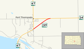
South Dakota Highway 249 (SD 249) is a state highway in the U.S. state of South Dakota that extends from SD 47 to SD 34 in Buffalo County. The entire highway is located within Fort Thompson and is maintained by the South Dakota Department of Transportation (SDDOT). It is not a part of the National Highway System.
Route description
SD 249 begins in Fort Thompson at an intersection with SD 47 and treks northeast through open plains. The roadway continues in this direction for about one mile (1.6 km) before curving to the east and merging with SD 34. SD 249 terminates at this intersection.[2][3] The route is maintained by SDDOT. In 2012, the traffic on the road was measured in average annual daily traffic. The highway had an average of 500 vehicles.[1]
Major intersections
The entire route is in Fort Thompson, Buffalo County.
| mi[1] | km | Destinations | Notes | ||
|---|---|---|---|---|---|
| 0.000 | 0.000 | Southern terminus | |||
| 1.055 | 1.698 | Northern terminus | |||
| 1.000 mi = 1.609 km; 1.000 km = 0.621 mi | |||||
References
- 1 2 3 "State Highway Log" (PDF). South Dakota Department of Transportation. January 2012. Retrieved March 9, 2013.
- ↑ Google (March 9, 2013). "South Dakota Highway 249" (Map). Google Maps. Google. Retrieved March 9, 2013.
- ↑ South Dakota Atlas & Gazetteer. Yarmouth, ME: DeLorme. 2009. pp. 24, 25. ISBN 0-89933-330-3.
External links
The Unofficial South Dakota Highways Page