South Dakota Highway 26
| ||||
|---|---|---|---|---|
|
Route of SD 26 (in red) | ||||
| Route information | ||||
| Defined by SDCL §31-4-149 | ||||
| Maintained by SDDOT | ||||
| Length: | 50 mi (80 km) | |||
| Existed: | 1935 (approx.) – present | |||
| Major junctions | ||||
| West end: |
| |||
| East end: |
| |||
| Location | ||||
| Counties: | Hyde, Hand, Spink | |||
| Highway system | ||||
| ||||

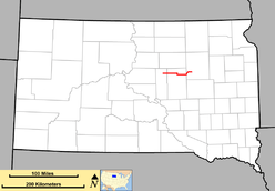
South Dakota Highway 26 (SD 26) is a state route that runs across central and northeast South Dakota. It begins at a junction with South Dakota Highway 47 north of Highmore, and terminates at U.S. Highway 281 just south of Redfield. It is 50 miles (80 kilometers) in length.
Route description
South Dakota Highway 26 begins at an intersection with SD 47 in Hyde County and travels east for about seven miles before entering Hand County. Sixteen miles east of the county, SD 26 turns south and begins a one-mile concurrency with SD 45. After this concurrency, SD 26 runs east for fifteen more miles before entering Spink County. Immediately east of the Hand–Spink county line, the highway curves north and runs along the shore of Cottonwood Lake. A few miles farther north, SD 26 curves to the east and heads in this direction for approximately five miles before terminating at US 281 south of Redfield.[1]
SD 26 does not run through any incorporated towns. The route of SD 26 is defined in South Dakota Codified Laws § 31-4-149.[2]
History
The current alignment is the second use of the SD 26 identifier.
The original SD 26 was implemented in the late 1920s. It began at South Dakota Highway 25 west of Bryant, and ran east to U.S. Route 77 near Estelline. This route was redesignated as South Dakota Highway 28 around 1934.
The current SD 26 was implemented around 1935, replacing what had been South Dakota Highway 22. At that time, the west terminus was at South Dakota Highway 45. The extension to the west was completed around 1962. A further extension west to U.S. Route 83 near Onida was planned in the 1970s, but was not implemented.
Major intersections
| County | Location | mi | km | Destinations | Notes |
|---|---|---|---|---|---|
| Hyde | | 0.00 | 0.00 | ||
| Hand | | North end of SD 45 concurrency | |||
| | South end of SD 45 concurrency | ||||
| Spink | | ||||
1.000 mi = 1.609 km; 1.000 km = 0.621 mi
| |||||
References
- ↑ "Google Maps Overview of SD 26". Retrieved November 3, 2012.
- ↑ "South Dakota Codified Law". Retrieved November 3, 2012.