Spaarnwoude
Coordinates: 52°24′N 4°42′E / 52.400°N 4.700°E
| Spaarnwoude | ||
|---|---|---|
|
Spaarnwoude village | ||
| ||
 | ||
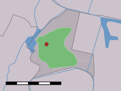 The village (dark red) and the statistical district (light green) of Spaarnwoude in the municipality of Haarlemmerliede en Spaarnwoude. | ||
| Country | Netherlands | |
| Province | Noord-Holland | |
| Municipality | Haarlemmerliede en Spaarnwoude | |

Spaarnwoude is a hamlet in the Dutch province of North Holland. It is a part of the municipality of Haarlemmerliede en Spaarnwoude, and lies about 5 km northeast of Haarlem.
The statistical area "Spaarnwoude", which also can include the surrounding countryside, has a population of around 200.[1]
North of Spaarnwoude lies the Spaarnwoude recreation area, which is located in the municipalities of Velsen and Haarlemmerliede en Spaarnwoude.
There is a railway station - Haarlem Spaarnwoude (Hlms) lies southwest of the village. An IKEA shop is nearby, on the north side. To the east of IKEA is the Veerplas.
Spaarnwoude was a separate municipality until 1857, when it merged with Haarlemmerliede.[2]
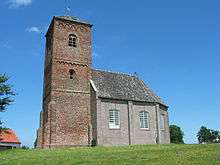
The church of Spaarnwoude
See also
External links
- Map of Spaarnwoude.
- J. Kuyper, Gemeente Atlas van Nederland, 1865-1870, "Spaarnwoude". Map of the former municipality, around 1868.
References
- ↑ Statistics Netherlands (CBS), Statline: Kerncijfers wijken en buurten 2003-2005. As of 1 January 2005.
- ↑ Ad van der Meer and Onno Boonstra, Repertorium van Nederlandse gemeenten, KNAW, 2006.
This article is issued from Wikipedia - version of the 9/18/2015. The text is available under the Creative Commons Attribution/Share Alike but additional terms may apply for the media files.