Spalato (Italian province)

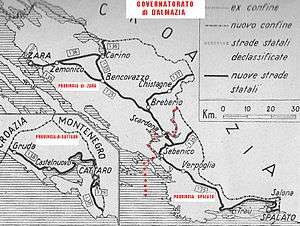
Spalato (Italian province) (or "Spalato province") was a province of the Italian Governorate of Dalmatia, during World War II. It was officially called in Italian: Provincia italiana di Spalato.
History

In April 1941 the Italians conquered coastal Dalmatia from the Kingdom of Yugoslavia. They created some provinces in that region, that lasted until September 1943. One was the province of Spalato. The administrative capital was the city of Spalato (now: Split).[1]
The province had an area of 1075 Km2 and a population of 128,000 inhabitants. Most of the province's inhabitants were Croats, but there were even more than 3,000 Dalmatian Italians, concentrated in Spalato and Traù (now: Trogir). The Italian island of Lagosta was united to the province.
The Italians improved the region in summer 1941 by building hospitals and infrastructures, mainly in the city of Spalato, but even started a process of forced Italianization (because related to the history of Venetian Dalmatia[2]). Because of this, in summer 1942 there was a small insurrection of Croats against the Italian conquest, but without huge consequences until spring/summer 1943. However, in spring 1942 was created the football team "Associazione Calcio Spalato", that was ruled by the Italian FIGC in the Italian championships. Meanwhile, in 1941 and 1942 many Jews and some Serbs took refuge in the city, escaping from the nearby regions ruled by the Croatian Ustaše.
In September 1943 the German army took control of the region from the Italians, who has surrendered to the Allies, and soon started a terrible guerrilla war between the Nazi occupiers and Joseph Broz Tito's partisans. The province was cancelled in the same September and later annexed to Ante Pavelic's Croatia.
Administrative subdivision
The 15 "Comuni" were (in Italian the official name and in Croatian the actual):
- Spalato / Split
- Blatta / Blato
- Castella Inferiore o Castel Vecchio / Kaštel Stari o Donji Kaštel
- Castelli / Kaštel Sućurac
- Castel Vitturi / Kaštel Lukšić
- Comisa / Komiža
- Curzola / Korčula
- Lagosta / Lastovo
- Lissa / Vis
- Meleda / Mljet
- Solta / Šolta
- Traù / Trogir
- Vallegrande / Vela Luka
See also
Notes
- ↑ Davide Rodogno. "Fascism European Empire". Section:Yugoslavia
- ↑ Treccani:Spalato (in Italian)
Bibliography
- Rodogno, Davide. Il nuovo ordine mediterraneo, ed. Bollati Boringhieri. Turin, 2003
Coordinates: 43°30′00″N 16°26′00″E / 43.5000°N 16.4333°E