Sparrows Herne Turnpike Road
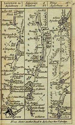
Sparrows Herne Turnpike Road was an 18th-century English turnpike road from London to Aylesbury. The route was approximately that of the later A41 trunk road, (excluding the modern bypass sections at Watford and Hemel Hempstead), and much of the original route is now numbered as the A4251. It followed the Edgware Road and ran through Watford, Kings Langley, Apsley, the Boxmoor area of Hemel Hempstead, Berkhamsted and Tring. It linked in with other turnpikes to the north forming a route to Birmingham.
The turnpike trust was set up in 1762 by around 300 landed gentry to look after about 26 miles of road between Sparrows Herne near Bushey and Walton near Aylesbury. It was the turnpike's depot at Sparrows Herne which gave the road its name.
The frequent use of the route by heavy carts carrying grain to London made it notorious for its rutted and pitted state even after being made into a turnpike.
The turnpike survived the coming of the railways until 1872,[1] when it passed to the route's various parishes and highway boards to maintain and the tolls were removed.
Description
The original turnpike gates were:
- Watford Gate at the bottom of Chalk Hill.[2]
- Ridge Lane Gate on the North side of Watford.
- New Ground Gate just to the south of Tring near New Ground Farm,
- Veeches Farm Gate, west of Aston Clinton – this was moved to Aylesbury in 1827 after the road was extended there.
- In 1860 another gate was established at the top of Tring Hill.[3]
Brick toll houses for these gates were built at a cost of around £25 each. Tollkeepers were appointed and paid 10s/6d a week for which they had to man the gate day and night and from which money they had to pay for the oil for the nighttime illumination of the gates with lamps.
In 1762 the maximum rate for tolls were:
- Horse or beast drawing a coach - 3d
- Packhorse (laden) - 1½d
- Drove of oxen, cows etc. - 10d per score
- Drove of sheep, calves, swine - 5d per score.
References
- ↑ Nunn, JB (1987). The Book of Watford. Watford: Pageprint (Watford) Ltd. ISBN 0-9511777-1-0.
- ↑ Sparrow Herne Trust Turnpike Marker, Lower High Street, Watford, Images of England, English Heritage National Monuments Record.
- ↑ Turnpike Post Opposite Brook Street, London Road, Tring, Images of England, English Heritage National Monuments Record.
- Humphreys, A. L. 'Records of Turnpike Trusts : Sparrows Herne'. in Notes and Queries, 180 (1941), 211-13.
- Littlefair, K. The Life of the Sparrows Herne Turnpike Trust 1762–1873 (1968 Dissertation, University of Exeter)
External links
- Transport At Watford History
- Edgware At British Online History
- The Chiltern Canal Corridor Castle Wharf project Berkhampstead. Accessed April 2007
- Strip Map from London to Aylesbury, Bowles's Post Chaise Companion, 1782.
Coordinates: 51°44′58″N 0°32′03″W / 51.7495°N 0.5343°W