Spithead
Coordinates: 50°45′05″N 1°08′12″W / 50.75140°N 1.13667°W

Map showing the location of Spithead within the United Kingdom.
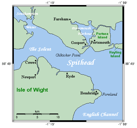
Closeup map of Spithead
Spithead is an area of the Solent and a roadstead off Gilkicker Point in Hampshire, England. It is protected from all winds, except those from the southeast. It receives its name from the Spit, a sandbank stretching south from the Hampshire shore for 5 km (3.1 mi); and it is 22.5 km (14.0 mi) long by about 6.5 km (4.0 mi) in average breadth. Spithead has been strongly defended since 1864 by fortifications complementing those of Portsmouth.
The Fleet Review is a British tradition that usually takes place at Spithead, where the monarch reviews the massed Royal Navy.
In 1797 there was a mutiny, the Spithead mutiny, in the Royal Navy fleet at anchor at Spithead.
This article is issued from Wikipedia - version of the 5/1/2016. The text is available under the Creative Commons Attribution/Share Alike but additional terms may apply for the media files.