Sredets Point

Sredets Point (Bulgarian: нос Средец, ‘Nos Sredets’ \'nos sre-'dets\) is the ice-covered point on the southeast coast of Smith Island in the South Shetland Islands, Antarctica, projecting 400 m into Osmar Strait and separating the glacier termini of Krivodol Glacier to the north and Pashuk Glacier to the south.
The point is named after the town of Sredets in Southeastern and the settlements of Sredets in Southern Bulgaria.
Location
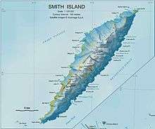
Sredets Point is located at 63°00′10.4″S 62°28′18″W / 63.002889°S 62.47167°WCoordinates: 63°00′10.4″S 62°28′18″W / 63.002889°S 62.47167°W, which is 16.9 km southwest of Cape Smith, 16.3 km northeast of Cape James and 3.4 km southeast of Antim Peak. Bulgarian mapping in 2009 and 2010.
Maps
- L.L. Ivanov. Antarctica: Livingston Island and Greenwich, Robert, Snow and Smith Islands. Scale 1:120000 topographic map. Troyan: Manfred Wörner Foundation, 2009. ISBN 978-954-92032-6-4
- Antarctic Digital Database (ADD). Scale 1:250000 topographic map of Antarctica. Scientific Committee on Antarctic Research (SCAR), 1993–2016.
References
- Bulgarian Antarctic Gazetteer. Antarctic Place-names Commission. (details in Bulgarian, basic data in English)
- Sredets Point. SCAR Composite Antarctic Gazetteer.

This article includes information from the Antarctic Place-names Commission of Bulgaria which is used with permission.