St George's Fields
Coordinates: 51°29′55″N 0°6′18″W / 51.49861°N 0.10500°W
St George's Fields was an area of Southwark in South London, England.[1]
Bermondsey Priory
Originally the area was an undifferentiated part of the south-side of the Thames, which was low lying marshland unsuitable for even agricultural purposes. As such it was part of the extensive holdings of the king, it is difficult to identify it in the Domesday Book. Shortly after the foundation of Bermondsey Priory the Cluniac order there began to acquire properties neighbouring their home manor. The Priory approached Henry I in 1103/04 to acquire what was held directly by the crown there. This was all of the territory on the western side of the high street, (Borough High Street, Southwark). In the conveying grant it was described as ‘the hide of Southwark’, i.e. of one hide, as a part of the king’s demesne.
Therefore, Bermondsey Priory had control of most of the Southwark area, its 'home' manor excepting the The Borough and the eastern side of the high street which had already been within the ownership of the Archbishop of Canterbury, which divided the Priory's holdings. However, another gift of land and a church created an anomaly. The Canterbury holding on the eastern side of the high street had a small part detached from it. This, at least in part, derives from what was the small de Ardern family property which occupied the corner of the junction of the high street and ‘old’ Kent street (now Tabard Street), presumably this had been acquired from Canterbury after 1086. It may have been a hamlet that had congealed at what is the junction of the Roman roads now known as 'Stane Street' and 'Watling Street'. This too was given to Bermondsey Priory in 1122, by the Ardern's along with St George the Martyr church which is in that precinct. It clearly is in the 'wrong' manor as the high street is the natural border. However, at the period under scrutiny it was just a small part of the extensive combined area held by the Priory occupying the western side of the high street, which as shown above was already owned by it. This area is coincident with the western part of the ancient parish of St George. Obviously, this largely open area was assigned to that church as an administrative convenience. Hence the area was designated as 'St George's Fields', although largely unpopulated. The Rectors were appointed by the Priory/Abbey until the Reformation changes and its dissolution.
Brandon family
The manorial area was informally referred to as 'le weste socne' (i.e. the ‘soke’ west of the ‘high’ street) in the thirteenth century Rolls and as the Abbot's manor later. From some point in the fifteenth century the Brandon family became the King’s Marshals; as such they controlled the two ancient royal prisons on the eastern side of the high street, the King's Bench and the Marshalsea. As they became more prominent at court they grew wealthier and acquired parts of the western side of the high street from the Abbey to create a large mansion and grounds including, notably, Moulton Close which is now Geraldine Mary Harmsworth Park around the Imperial War Museum. The house became known as Brandon Place. Charles Brandon, the last of the male line, became Marshal in 1510 and was created Duke of Suffolk in 1514; he married Henry VIII's sister in 1516. The mansion then becomes known as Suffolk Place. Charles died in 1545, but not before he disposed of the family home.
Property of the Crown
Henry VIII took an interest in Suffolk Place and acquired it from Charles in 1536. Shortly after, in June 1536, the St Saviour’s Abbey of Bermondsey was induced to 'grant' its land to the king, part of the Dissolution process, hence he now owned all of the Abbey’s manor west of the high street. However, Henry VIII gave this building to Queen Jane Seymour in 1537, mother of Edward VI, who died of post-natal complications shortly after his birth. It seems it was Henry's intention to create a new hunting park out of the two areas and the Brandon mansion was to act as its lodge. In any case Henry seems to have lost interest in the project before his death in 1547.
Property of the City
The manor belonged to the Crown for only fourteen years, as in 1550 the City acquired it from Edward VI's government and also the Canterbury manor on the east side of the high street. The 'Abbot's' manor became known as 'The King's Manor'. This was presumably because of the royal presence at the old Suffolk House. This had been specifically excluded from the City’s jurisdiction by clauses in the 1550 charter. The building remained a royal mansion; in 1554 Queen Mary stayed overnight with her new husband King Philip II of Spain as part of their progress to London. The City's jurisdiction in Southwark now stretched across from the various borders with Lambeth and Bermondsey. These lands were paid for through the use of the endowments of the Bridge House Estates. From this point the City nominated the Rector of St George's, as to the present day.
The City's control of the area of St George's Fields allowed its development. From 1750 the creation of the new roads associated with the new Westminster Bridge and the improvements to the old London Bridge created the traffic nexus at Newington which because of these changes became known as Elephant and Castle and the junction of St George's Circus was required to connect these with the later, 1769 Blackfriars Bridge Road / London Road. The City also decided to relocate from Moorfields the Bethlem Royal Hospital 1815. The location at the edge of the territory it had control of in St George's Fields, the site of the Dog and Duck tavern, was thought at the time to be sufficiently rural for the institution but also convenient to the built up area.
St George's Fields was the scene of riots in 1768, agitating for the release of John Wilkes and, more seriously, was the starting point of the Gordon Riots in 1780 which began in the movement to repeal the act of parliament removing penalties for Catholics.
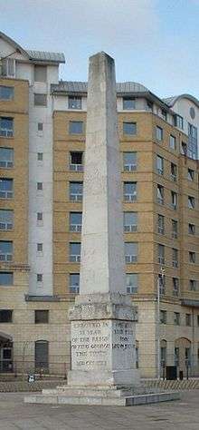
The obelisk at St George's Circus
The obelisk at St George's Circus was built in 1771 in honour of Brass Crosby, the Lord Mayor of the City of London. It was moved to the north apex of Geraldine Mary Harmsworth Park, (the remnant of Multon Close) a short distant southwest, in front of the museum, in 1905, and put back in its original spot in the late 1990s.
St George's Cathedral, Southwark
St George's Cathedral, Southwark, designed by Augustus Pugin, was considered the most important Catholic Church in England when it was built. It could seat about 3,000 persons, and the building was 240 feet long by 72 feet wide. The church was solemnly opened by Bishop Wiseman on 4 July 1848. To mark the occasion Pope Pius IX sent a golden chalice and paten as a gift. Two years later Pope Pius IX restored the English hierarchy and St George's was chosen as the Cathedral Church of the new Diocese of Southwark, which was to cover the whole of Southern England. For the next half-century, until the opening of Westminster Cathedral, St George's was the centre of Catholic life in London.
See also
References
- ↑ Ida Darlington, ed. (1955). Survey of London. 25 - St George's Fields (The parishes of St. George the Martyr Southwark and St. Mary Newington). British History Online.